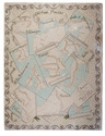
Finely engraved wall map of the Rijnland water district, coloured by a contemporary hand
DOU, Jan Jansz. (Johannes Dou I), Steven van BROECKHUYSEN and Melchior BOLSTRA.
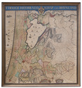
'T Hooge Heemraedschap van Rhynland.
[Amsterdam, Isaak Tirion], 1746. Very large engraved wall map of the Rijnland water district in 12 map sheets and 1 title-sheet, the title-sheet divided into 3 strips, the whole mounted on cloth (measuring 185 x 169 cm as assembled). Coloured and shellacked by a contemporary hand, with gold for the lettering of the title and the coat of arms. With the water board's coat of arms, and two decorative cartouches listing the members of the water board in 1687 and 1746. Framed. Full description
€ 7,500
[Amsterdam, Isaak Tirion], 1746. Very large engraved wall map of the Rijnland water district in 12 map sheets and 1 title-sheet, the title-sheet divided into 3 strips, the whole mounted on cloth (measuring 185 x 169 cm as assembled). Coloured and shellacked by a contemporary hand, with gold for the lettering of the title and the coat of arms. With the water board's coat of arms, and two decorative cartouches listing the members of the water board in 1687 and 1746. Framed. Full description