Categories
Shopping cart (0 items € 0)
Advanced search

Cartography & Exploration / Low Countries

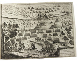
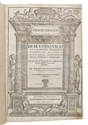
Manuscript plan of the "Stelling Den Helder": the oldest surviving defence line in Dutch military history, including the important marine shipyard Willemsoord

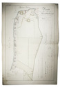
[FORTIFICATION PLAN - DEN HELDER - WILLEMSOORD]. KRAG, Rasmus. 
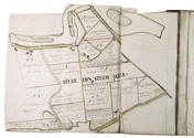
Kort over en deel af provindsen Nordholland med befestningen af de Helder, maritime & etablissementet Willemsoort samt en deel af den nye Nordhollandske Canal.
[The Netherlands?], 1825. Double Elephant 1mo sheet (92 x 63 cm). With a pen and ink-drawn fortification plan (ca. 85 x 55 cm) of the Den Helder fortifications and the marine shipyard Willemsoord, coloured by a contemporary hand, with a manuscript title, scales and a key in Danish, written in a fine and legible 19th-century hand surrounding the plan. On Whatman wove paper. Folded. [1] sheet. Full description
€ 1,800
Order Inquire Terms of sale

A general in the Spanish army on the battles and sieges in Flanders 1601-1609,
during the Dutch war for independence, with 29 folding maps and plans

GIUSTINIANO, Pompeo. Delle guerre di Flandra libri VI. ... Posti in luce da Gioseppe Gamurini ...
Antwerp, J. Trognesio, 1609. 4to. With engraved architectural title-page and 29 folding engraved maps and plans of sieges and fortifications. White sheepskin (ca. 1700 or possibly later). [4], 329, [1 blank], [15], [3 blank] pp. Full description
€ 2,950
Order Inquire Terms of sale

19th-century Muiden and Laren

[GOOI - NETHERLANDS]. Gezichten langs den Gooischen stoomtram.
[Amsterdam], E. van Elfrinkhoff, [ca. 1893]. (Ca. 22.5 x 17.5 cm). With the title-page and each of the 12 photographs (12 x 17 cm) pasted on paperboard (17 x 22 cm), the photographs with printed titles below. Contemporary paperboard box. Full description
€ 1,250
Order Inquire Terms of sale

12 engraved views and costumes from North Holland

GREEVEN, Hendrik. Tableaux des costumes, moeurs, coutumes et vues, de la Nord-Hollande, de Zaandam, Broek, Alkmaar, Assendelft et de l'Île de Marken.
Amsterdam, Evert Maaskamp, [ca. 1826]. Oblong 4to (22.5 x 29 cm). With an engraved map of North Holland by C.H. Koning on title-page and 11 engraved plates, mostly engraved by Willem van Senus after Hendrik Greeven, all protected by tissue guards. Contemporary boards; preserved in a modern cloth clamshell box. [2] ll. + 10 plates. Full description
€ 1,750
Order Inquire Terms of sale

Italian fortification atlas of the Low Countries

GUALDO PRIORATO, Galeazzo. Teatro del Belgio ò sia descritione delle diecisette provincie del medesimo; con le piante delle città, e fortezze principali; da chi al presente possesse; come, in qual modo, & in qual tempo acquistate.
Vienna, Michael Thurnmayer, 1673. Folio. With engraved frontispiece with the coat-of-arms of all Seventeen Provinces, engraved military scene on the title-page, folding engraved map of the Low Countries, 2 folding engraved views of a sea-battle and an army crossing the Rhine, and 120 double-page engraved fortification plans. Contemporary mottled sheepskin, gold-tooled spine. [14], 148, [6] pp. text Full description
€ 5,000
Order Inquire Terms of sale

First edition of Guicciardini's celebrated 16th-century description of the Low Countries

GUICCIARDINI, Ludovico. Descrittione ... di tutti i Paesi Bassi, altrimenti detti Germania Inferiore.
Antwerp, Willem Silvius, 1567. Folio. With the title, the large coat of arms of Philip II, and his portrait set within a woodcut architectural frame with allegorical figures on separate pages, 5 double-page woodcut maps (including 1 folding), 4 double-page woodcut views of cities, 6 double-page woodcut plans of cities, and 2 double-page illustrations of buildings (1 woodcut, 1 engraved). Further with 15 woodcut divisional title-pages for the illustrations and descriptions of the regions and cities set within a woodcut ornamental frame and numerous woodcut decorated initials (at least 4 series) Later overlapping vellum, sewn on 3 parchment tapes laced through the joints. [3], [1 blank], [16], "296"[= 339], [1 blank], [19], [1 blank] pp. Full description
€ 7,500
Order Inquire Terms of sale

Hand-coloured engraved map showing the rivers of Germany and the Low Countries

[MAP - GERMANY - LOW COUNTRIES]. HOMANN, Johann Baptist. Hydrographia Germaniae qua geographiae naturalis ea pars quae de aquis celebrioribus praesertim vero de fluminibus Germaniae agit...
Nuremberg, Johann Baptist Homann, [ca. 1710?]. Engraved map (48.5 x 58 cm) on a whole sheet of paper (53 x 63.5 cm), coloured in an early hand, with the title in an illustrated cartouche with Neptune and other mythological figures at lower left, an illustrated cartouche at upper left with a coat of arms, and a scale (ca. 1:2,400,000) in the margins. Full description
€ 200
Order Inquire Terms of sale

Rare 18th-century wall map of the Netherlands

[MAP - NETHERLANDS]. [LE ROUGE, George-Louis]. La Hollande en 12 feuilles.
Paris, Jean Dezauche, 1790. Published on 12 sheets, numbered as 48 quarter-sheets. An engraved wall map of the Netherlands (excluding Zeeland), with the main title in a large cartouche at upper left, the Latin title at upper right. Many cities and coastlines, and a few other features, highlighted in colour. Cut, mounted on cloth and folded, in 4 contemporary gold-tooled green morocco boxes. Full description
€ 8,500
Order Inquire Terms of sale

Illustrated travel guide to Belgium, with 3 engraved folding maps

[MAASKAMP, Evert]. Reis door België in het jaar 1814.
Amsterdam, Evert Maaskamp; Brussels, P.J. de Mat, 1815. 8vo. With a lithographed title-page, 3 folding engraved plates (1 hand coloured in outline), 3 aquatint plates printed in sepia, 2 engraved plates printed in sepia (1 double-page) and 2 hand-coloured engraved plates. Contemporary half tanned sheepskin. XX, 200, [2 blank], [10] pp. Full description
€ 1,250
Order Inquire Terms of sale

Charming aquatints of Dutch historical monuments and folklore

[MAASKAMP, Evert (editor)]. Merkwaardige gezigten, gebouwen, monumenten en standbeelden in de noordelijke provintien van het Koningrijk der Nederlanden. | Vues remarquables, edifices, monumens et statues dans les provinces septentrionales du Royaume des Pays-Bas.
Amsterdam, Evert Maaskamp, 1816. Oblong 8vo. With an engraved illustration on title-page and 37 sepia aquatints by Ludwig Portman after Gerrit Jan Michaëlis, Franciscus Aandreas Milatz, and Cornelius Overman. Contemporary gold-tooled dark blue boards. [40] ll. + 37 plates. Full description
€ 1,750
Order Inquire Terms of sale
49 books found / Show all