
Field guide for officers during the Mesopotamian campaign (1914-1918), with a folding map
[MESOPOTAMIA]. [Indian Army General Staff].
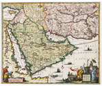
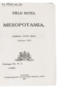
For official use only. Field notes. Mesopotamia. General staff, India. February 1917.Including: Index to field notes, Mesopotamia, 1917.
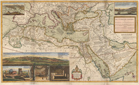
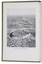
Calcutta, Superintended government printing, 1917. Small 8vo. With 1 folding heliozincographed map of "Lower Mesopotamia", with some routes in red, and three folding letterpress tables. Original green cloth. [3], [1], 326(=325), [1]; [1], [1 blank], XX pp. Full description
€ 6,500
Calcutta, Superintended government printing, 1917. Small 8vo. With 1 folding heliozincographed map of "Lower Mesopotamia", with some routes in red, and three folding letterpress tables. Original green cloth. [3], [1], 326(=325), [1]; [1], [1 blank], XX pp. Full description