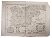
Categories
Shopping cart (0 items € 0)
Advanced search

Cartography & Exploration

Peace in Goa between the Portuguese and Sawantwadi, with transcriptions of treaties

MASCARENHAS, José Freire de Monterroio. Noticia da viagem, que fez segunda vez ao estado da India o ... senhor Marquez do Louriçal, e primeiros progressos do seu governo.
Lisbon, Luiz Jozé Correa Lemos, 1742. Small 4to (20.5 x 15 cm). With a Maltese cross on the title-page, a woodcut headpiece and a woodcut decorated initial. Later marbled stiff paper wrappers, new endpapers. 24 pp. Full description
€ 3,500
Order Inquire Terms of sale

First edition of a report - with the rare folding map - from Commodore Perrys expedition containing directions for U.S. merchant ships navigating the coasts of China and Japan

MAURY, William Lewis & Silas BENT. Sailing directions and nautical remarks; by officers of the late U.S. naval expedition to Japan, under the command of Commodore M.C. Perry.
Including (with a divisional title): Fac-simile of the original treaty with Japan, with the English version.
Washington, A.O.P. Nicholson, public printer, 1857. Large 4to (ca. 29.5 x 23 cm). With a large folding map of the coast of China and of the Japanese and other islands, including the Marianas and the Philippines; and the facsimile of the 14-page treaty in Japanese printed on both sides of 7 integral leaves, with the English text printed letterpress on both sides of the following leaf. Original publishers half purple cloth, Spanish-marbled paper sides (grey with red, blue, black, yellow and white veins), letterpress paper label with the title in a built-up decorative border on the front board: "Sailing directions for the coasts of Japan and China". 22, [2], 14, [2] pp. Full description
€ 5,000
Order Inquire Terms of sale

Japan through the eyes of the last Dutch governor of Deshima (Nagasaki)

MEIJLAN, Germain Felix. Japan. Voorgesteld in schetsen over de zeden en gebruiken van dat ryk, byzonder over de ingezetenen der stad Nagasaky.
Amsterdam, M. Westerman & son, 1830. 8vo. With engraved title-page with hand-coloured vignette lightened with gold and 2 folding aquatint plates. Modern green half cloth, with the front of the original letterpress-printed wrappers mounted on front board and the back wrapper loosely inserted. [12], 190, [2 blank] pp. Full description
€ 3,500
Order Inquire Terms of sale

One of the greatest printing enterprises of the 17th century

MERIAN, Matthäus. Theatrum Europaeum. Beschreibung aller Geschichten so sich 1617[-1718] zugetragen haben.
Frankfurt am Main, Daniel Fievet, Johann Görlin et al., ca. 1633-1738. 21 vols. Folio (ca. 22 × 33.5 cm). With 19 (of 20) engraved title-pages, 1 engraved title vignette, 1 armorial plate, 646 (of 686) engraved views, plans, and maps, many folding or double-page-sized, 690 (of 692) engravings in the text (mostly portraits on interleaves), and several folding tables. Early 18th century full leather bindings with gold-tooled spines (titles and crown crest) and blind-tooled frame on the boards; slightly differing from vol. 16 onwards with gilt supralibros "Academ. Marburg.". Full description
€ 75,000
Order Inquire Terms of sale

A famous topography of Switzerland enlarged with 68 extra engravings

MERIAN, Matthäus. Topographia Helvetiae Rhaetiae et Valesiae. Das ist, Beschreibung und eigentliche Abbildung der vornembsten Stätte und Plätz, in der hochlöblichen Eydgnoßschafft, Grawbündten, Walliß, und etlicher zugewanten Orten.
[Frankfurt am Main], Matthäus Merian, 1642. Folio. With richly engraved title-page, 74 (of 76) engraved maps, plans and views on 54 (of 56) plates normally included the 1642 first edition (nearly all double-page) plus 1 large folding plate from the 1653 Anhang, and 67 additional engravings from the 17th and 18th century, including at least 16 by or after Merian. Altogether there are 3 general maps (1 of Germany and surroundings and 2 of Switzerland), 4 detail maps, and numerous city plans and views. Lacking the bird's eye view of Herisau and the second of two views of Neuchâtel. Tanned sheepskin (ca. 1700?), gold-tooled spine. 72, [8] pp. plus engraved plates. Full description
€ 29,500
Order Inquire Terms of sale

Field guide for officers during the Mesopotamian campaign (1914-1918), with a folding map

[MESOPOTAMIA]. [Indian Army General Staff]. For official use only. Field notes. Mesopotamia. General staff, India. February 1917.Including: Index to field notes, Mesopotamia, 1917.
Calcutta, Superintended government printing, 1917. Small 8vo. With 1 folding heliozincographed map of "Lower Mesopotamia", with some routes in red, and three folding letterpress tables. Original green cloth. [3], [1], 326(=325), [1]; [1], [1 blank], XX pp. Full description
€ 6,500
Order Inquire Terms of sale

The climate of the East African coast

[ARABIAN GULF]. Weather in the Indian Ocean to Latitude 30° S. and Longitude 95° E. Including the Red Sea and Persian Gulf. Volume II. Local information. Part 9 Coast of East Africa from the equator to Cape Delgado [...].
London, Meteorological Office, Air Ministry, 1940. 8vo. With map frontispiece and several illustrations and tables in the text. Original publisher's printed red wrappers. 63 pp., final blank page. Full description
€ 1,500
Order Inquire Terms of sale

Highly detailed maritime atlas

GREAT BRITAIN METEOROLOGICAL OFFICE. Monthly current charts for the Indian Ocean. From information collated & prepared in the Meteorological Office.
London, Admiralty Hydrographic Office, under the superintendence of Rear-Admiral W. J. L. Wharton, 1895-1896. Plano. Oblong Royal 1mo (full-sheet leaves: 51 x 62 cm). An atlas of 12 large black and white nautical charts. Limp cloth with gold-tooled title on front cover. [12] ll. plus the 1-page “Advertisement”. Full description
€ 3,500
Order Inquire Terms of sale
647 books found / Show all