Categories
Shopping cart (0 items € 0)
Advanced search

Middle East & Islamic World / Arabian Peninsula & Gulf States

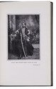
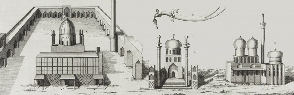
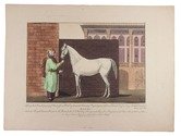
Only copy located of a hand-coloured print series of Arabian horses, after drawings made in Baghdad

RICH, Claudius James and Siegmund Ferdinand von PERGER. 
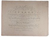
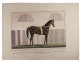
Sammlung und Darstellung verschiedener Pferde intressanter Zuchten, Landeskarten und Rassen ...
Vienna, Müllersche Kunsthandlung, 1815. Oblong folio (31 x 42.5 cm). Engraved print series, including a title-page engraved by Dorneck and 6 numbered engravings of horses engraved by Siegmund Ferdinand von Perger, hand-coloured and loose as issued. [1], VI engraved ll. Full description
€ 12,500
Order Inquire Terms of sale

Stunning double-tinted views of the Middle East, after drawings made in 1838 and 1839,
with 250 plates

ROBERTS, David, George CROLY and William BROCKEDON. The Holy Land, Syria, Idumea, Arabia, Egypt & Nubia.
London, Day & son (vol. 3: New York, D. Appleton & Co.), 1855-1856. 6 volumes bound as 3. Imperial 8vo (30 x 22 cm). With 250 numbered plates (including 6 tinted lithographed title-pages, 2 stone-engraved maps and 239 tinted and double-tinted lithographed and 2 chromolithographed views). Contemporary, richly gold-tooled reddish-brown morocco, gold-tooled turn-ins, marbled endpapers, gilt and gauffered edges. With thin paper guard leaves facing each plate. Full description
€ 18,000
Order Inquire Terms of sale

First and only publication of the original text of the primary logbook of the first Dutch expedition
to the Arabian Gulf by Cornelis Cornelisz Roobacker

[ROOBACKER, Cornelis Cornelisz.] A. HOTZ (publ.). Cornelis Cornelisz Roobacker's scheepsjournaal Gamron-Basra (1645); de eerste reis der Nederlanders door de Perzische Golf. Uitgegeven, met inleiding en noten, door A. Hotz.
In: BEEKMAN, A.A. etc. (eds.), Tijdschrift van het Koninklijk Nederlandsch Aardrijkskundig Genootschap gevestigd te Amsterdam. Tweede serie Deel XXIV. No. 3 (15 Mei).
Leiden, Brill, 1907. 8vo. One folding table and 3 folding maps (1 belonging to another article in the journal). Brown paper wrappers, with title information of the journal on the front and spine, and the contents on the back wrapper. 289-405 [=117] pp. Full description
€ 750
Order Inquire Terms of sale

A compendium for sailing the Indian Ocean, with three charts, second copy located

ROSSER, William Henry. Short notes on the winds, weather, & currents, together with general sailing directions and remarks on making passages; to accompany a chart of the Indian Ocean. With two[=three] illustrations.
London, James Imray and son, 1866. 8vo. With 3 folding lithographed charts (the first as frontispiece and the third possibly extra added). Modern brown cloth, spine with a long vertical leather title-label. [4], 64 pp. Full description
€ 3,500
Order Inquire Terms of sale

Sailing routes in the Indian Ocean and a general information about its weather, currents, etc. forecast,
with 2 maps showing the Persian Gulf, Red Sea and Gulf of Aden

ROSSER, William Henry. Short notes on the winds, weather, & currents, together with general sailing directions and remarks on making passages; to accompany a chart of the Indian Ocean.
London, James Imray & son, 1878. 8vo. With 2 folding maps. Original publishers blue wrappers. [4], 71 pp. Full description
€ 1,800
Order Inquire Terms of sale

5 original glass lantern slides with the earliest photographs of Mecca and Medina

SADIQ BEY, Muhammad, Christiaan SNOUCK HURGRONJE and Al-Sayyid ‘Abd al-GHAFFÂR. [5 photographic lantern slides of Mecca and Medina (silver gelatin glass positives), taken in the years 1880 to 1889].
Stuttgart, Lichtbilderverlag Theodor Benzinger, [ca. 1910]. 5 glass positive lantern slides (8.5 x 10 cm), each with a black paper mask, paper tape around the edges, a letterpress slip at the foot giving the publisher's name and city, and a slip at the head with the manuscript title. Kept in a contemporary purpose-made wooden box with brass fittings, with the word "Mekka" on the top of the hinged lid. Full description
€ 35,000
Order Inquire Terms of sale

Road map of Saudi Arabia, with plans of Jeddah, Riyadh and Dammam

[SAUDI ARABIA – MAP]. Road map of Saudi Arabia: accurate and most up to date road map.
[Saudi Arabia, 1960s]. Colour-printed folding map (48 x 69.5 cm) of the Arabian peninsula (scale: ca. 1: 5,000,000), with on the back a city map of Jeddah, a plan of the main business quarter of Riyadh, a city plan of Dammam(?), a distance table and 8 photographic city views. Full description
€ 1,800
Order Inquire Terms of sale

Road map of Saudi Arabia, with plans of Jeddah, Riyadh and Dammam

[SAUDI ARABIA – MAP]. Road map of Saudi Arabia: accurate and most up to date road map.
Karachi, Pakistan, printed at Golden block works, [1970s]. Colour-printed folding map (48 x 69.5 cm) of the Arabian peninsula (scale: ca. 1:5,000,000), with on the back a city map of Jeddah, a plan of the main business quarter of Riyadh, a city plan of Dammam(?), a distance table and 8 photographic city views. Full description
€ 1,750
Order Inquire Terms of sale
201 books found / Show all