Categories
Shopping cart (0 items € 0)
Advanced search

Cartography & Exploration / Voyages & Travel

Important collection of voyages to America and Africa, together with a standard work on Constantinople

[JUSTEL, Henri]. Recueil de divers voyages faits en Afrique et en l'Amerique.
Paris, Louis Billaine, 1674. With 17 engraved plates: 5 maps (4 folding), 3 folding plans and 9 other illustrations.
With: (2) GRELOT, Guillaume-Joseph. Relation nouvelle d'un voyage de Constantinople.
Paris, Nicolas Belley, 1689 (colophon 1680). With engraved portrait of a saint on title-page, 13 engraved plates, 4 engravings in text and engraved coat of arms. 2 works in 1 volume. 4to. 18th-century tan calf, gold-tooled spine. [16], 262, 35 [1 blank], 23 [1 blank], 49 [1 blank], [2], 81 [1 blank]; [12], 306, 1 [1 blank] pp. Full description
€ 18,000
Order Inquire Terms of sale

Important account of a journey through North America

KALM, Peter. Travels into North America.
London, T. Lowndes, 1772. 2 volumes. 8vo. With a large folding map (ca. 57×76.5 cm) of northeastern America depicting New England, New York, Pennsylvania, New Jersey, Connecticut, Rhode Island, Maryland, and parts of Virginia and Canada; an engraved view, and 5 plates of birds and mammals. Polished, tan calf (ca. 1800), with gold-tooled spine and board edges. [2], XII, 414; IV, 423, [8]. Full description
€ 1,750
Order Inquire Terms of sale

The main source of early knowledge of the Pelew or Palau Islands in Micronesia, in French translation

KEATE, George. Relation des Îles Pelew, situées dans la partie occidentale de l'océan pacifique; composée sur les journaux et les communications du Capitaine Henri Wilson, et de quelques-uns de ses Officiers, ...
Paris, Le Jay and Maradan, 1788. 2 volumes. 8vo. With engraved frontispiece portrait, engraved folding map of the Palau Islands, Philippines and the Chinese Sea, 12 folding engraved plates and 3 engraved portraits. Contemporary half calf, gold-tooled spines. [4], 282; [4], 274, [6] pp. Full description
€ 750
Order Inquire Terms of sale

The main source of early knowledge of the Pelew or Palau Islands in Micronesia, in Dutch translation

KEATE, George. Beschryving van de Pelew Eilanden ...
Rotterdam, Gerard Abraham Arrenberg, 1789. 4to. With 8 plates: 4 mixed technique (partly stipple-engraved) portraits, 1 large folding engraved map of the Palau Islands and western equatorial Pacific, and 3 folding engraved views. Contemporary boards. XXXII, 365, [1] pp. Full description
€ 2,500
Order Inquire Terms of sale

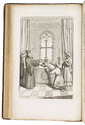
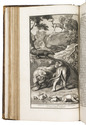
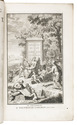
Very rare Dutch picaresque novel, with the female protagonist getting caught by pirates
and ending up in the household of an Arabic slave trader

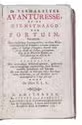
[KERSTEMAN, Petrus Lievens]. 
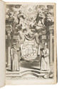
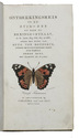
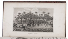
De vermakelyke avanturesse, of de dienstmaagd van fortuin. Vervattende hare zonderlinge levensgevallen, ontelbare wederwaardigheden en rampen; zeltzame ontmoetingen, en koddige vryagien; deszelfs driejarige dienst als lakye, gevangenneming op de Moorsche kusten, en hare slavernye in Asia by de Arabieren.
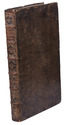
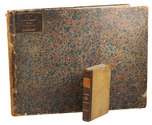
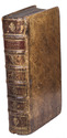
Amsterdam, Steven van Esveldt, 1754. 8vo. With engraved frontispiece. Contemporary mottled half calf, gold-tooled spine, later endpapers. [4], 360 pp Full description
€ 3,500
Order Inquire Terms of sale

Concise handbook for Western travellers visiting the Gulf States

KILNER, Peter and Jonathan WALLACE (editors). A guide for businessmen and visitors. The Gulf handbook 1978.
Bath and London, Trade and Travel Publications and MEED, 1978. 17.5 x 12 cm. With 8 sections of a map (2 full-page and 3 double-page) in colour of showing several parts of the Arabian peninsula, 8 full-page black-and-white photographic portraits of the Heads of State of the different Gulf States, 21 black-and-white maps and plans of these states and their largest cities, and numerous advertisements (partially in colour) throughout. Original illustrative printed boards, showing an Arab man with a gun in front of a large satellite dish and an advert for Arab Wings showing a plane in the sky on the back. XII, 576 pp. Full description
€ 350
Order Inquire Terms of sale

1824 description and atlas of the United States of America, with views of New York and Philadelphia

KLINKOWSTRÖM, Axel. Bref om de Förenta Staterna, författade under en resa till Amerika, ären 1818, 1819, 1820. ... Förra[-Senare] delen.
Stockholm, Ecksteinska Tryckeriet, 1824. 3 volumes, the 2 text volumes bound as 1. 8vo (text) & 1mo (atlas, 42 x 56 cm). Each text volume with the same engraved title-page, and in volume 1 a folding letterpress table. The atlas volume has a lithographed title-page with a view of the White House, 2 large engraved maps of the northern part and the southern part of the United States by John Melish, dated 1816, and 14 maps, plans and views of New York, Philadelphia and Washington, including 8 fine engraved aquatints by Akrell. Bound in the atlas volume are 2 letterpress 4to leaves, one with the numbered list of 19 plates: the 2 engraved title-pages for the text volumes (1-2), lithographed title-page for the atlas (3) and 16 plates for the atlas (4-19: seven are 1mo - full or nearly full sheets - and nine smaller).
With: (2) [KLINKOWSTRÖM, Axel]. Atlas til Friherre Klinckowströms Bref om de Förente Staterne.
[Stockholm, Ecksteinska Tryckeriet, 1824]. Contemporary half sprinkled calf with the volume numbers 1 & 2 in half tanned sheepskin. IX, 242, [2]; VIII, [2], 243-496 pp. Full description
€ 7,000
Order Inquire Terms of sale

The most richly illustrated edition of a famous description of South Africa

KOLB (KOLBE), Peter. Naaukeurige en uitvoerige beschryving van de Kaap de Goede Hoop.
Amsterdam, Balthazar Lakeman, 1727. 2 volumes bound as 1. Folio. With engraved title-page, engraved portrait of the author, 6 engraved maps (including one large folding map, 42.5 x 54.5 cm), 1 engraved plan and 45 engraved plates. 18th-century tanned sheepskin with a tree pattern, gold-tooled spine. [20], 529; [6], 449, [87] pp. Full description
€ 7,500
Order Inquire Terms of sale
354 books found / Show all