
"Not to be Published"
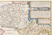
[IRAQ DESERT]
2 lithographic WWII maps: Rutba and Wadi Al Ubaiyidh.
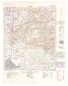
[UK Government], Geographical Section, General Staff, War Office, 1940-1942. 2 topographic maps, colour-printed. Scale 1:500,000. 820 x 640 mm and 770 x 648 mm. Previously folded. Marked "Iraq Desert Sheet 1" and "Sheet 2". Generally well preserved. Full description
€ 1,250
[UK Government], Geographical Section, General Staff, War Office, 1940-1942. 2 topographic maps, colour-printed. Scale 1:500,000. 820 x 640 mm and 770 x 648 mm. Previously folded. Marked "Iraq Desert Sheet 1" and "Sheet 2". Generally well preserved. Full description