
19th-century panorama of Mazatlán, Mexico
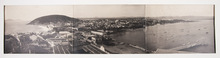
[PHOTOGRAPHY - MEXICO]. GONZALEZ, F.M.
[Panoramic photograph overlooking Mazatlán].
[Mexico, ca. 1880-1900]. Albumen print (ca. 17 x 71 cm) in 3 parts with photographer's credit in white in the negative, mat mount. Pasted on heavily spotted and browned contemporary wove paper. Full description
€ 2,500
[Mexico, ca. 1880-1900]. Albumen print (ca. 17 x 71 cm) in 3 parts with photographer's credit in white in the negative, mat mount. Pasted on heavily spotted and browned contemporary wove paper. Full description