Categories
Shopping cart (0 items € 0)
Advanced search

Cartography & Exploration / Americas

A great work on Peru: the first full atlas, together with an extensive statistical description

PAZ SOLDAN, Mariano Felipe. Atlas geografico del Peru.
Paris, Firmin Didot brothers, children and comp., 1865. Large folio (51.5 x 37.5 cm). With 50 engraved maps, plans and views (including 20 coloured) and 24 tinted lithographs by F. Delamare. Contemporary black half sheepskin, rebacked. [2], 82 pp. Full description
€ 5,500
Order Inquire Terms of sale

The land, indigenous peoples and colonists in Nova Scotia, by a French official spying for England

[PICHON, Thomas]. Lettres et memoires pour servir à l'histoire naturelle, civile et politique de Cap Breton, ...
The Hague, Pierre Gosse; London, Jean Nourse [printed in England], 1760. 12mo. Half brown morocco (ca. 1885?), by Frank J. Pfister in New York, gold-tooled spine, round gold stamp of Henry Gurdon Marquand on the front. XVI, 327, [1 blank] pp. Full description
€ 1,250
Order Inquire Terms of sale

Exploring New Mexico and Louisiana and searching for the source of the Mississippi,
while unknowingly supporting plans for empire in the Southwest

PIKE, Zebulon Montgomery. Reize naar Nieuw-Mexico en de binnenlanden van Louisiana, voorgegaan door eenen togt naar de bronnen der Mississippi.
Amsterdam, Cornelis Timmer (colophon: printed by A. Breeman & Co.), 1812. 2 volumes. 8vo. With 3 engraved folding maps: the first two showing the interior of Louisiana and the third the Mississippi River. Contemporary half calf, gold-tooled spine. VIII, 327, [1]; [4], 374 pp. Full description
€ 4,950
Order Inquire Terms of sale

Portuguese classic of practical navigation, with 36 maps and nautical charts

PIMENTEL, Manuel. 
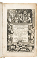
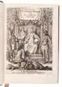
Arte de navegar, em que se ensinão as regras praticas, e os modos de cartear, e de graduar a Balestilha por via de numeros, e muitos problemas uteis aì navegação, e roteiro das viagens, e costas maritimas de Guineì, Angola, Brazil, Indias, e Ilhas Occidentaes, e Orientaes ...
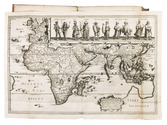
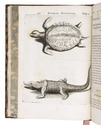
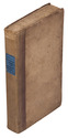
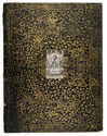
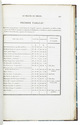
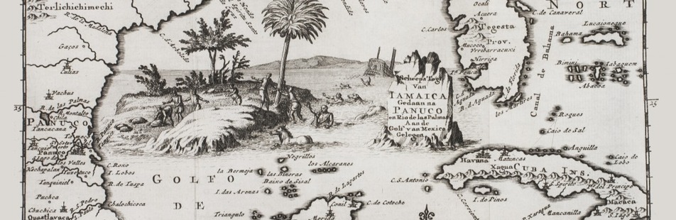
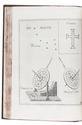
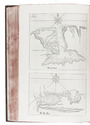
Lisbon, Miguel Manescal da Costa, 1762. Folio (30 x 20.5 cm). With 21 engraved plates (1 folding), 1 nearly full-page engraving of a compass rose and about 10 woodcut diagrams in the text. Contemporary or near contemporary tanned sheepskin, richly gold-tooled spine, new endpapers. [12], 603, [1] pp. Full description
€ 5,000
Order Inquire Terms of sale

Only published edition of the original 1521 text of the navigation book of the great Ottoman admiral

PIRI REIS (Paul KAHLE, ed.). Bahrije. Das türkische Segelhandbuch für das Mittelländische Meer vom Jahre 1521.
Berlin and Leipzig, Walter de Gruyter & Co., 1926-1927. 3 volumes. Large 8vo (26 x 18 cm). Volume 1 with 137 reproductions of manuscript pages of Ottoman Turkish text and maps and volume 2 with 4 plates. Publisher's original printed wrappers. [1], [1 blank], [2] pp. + 64 ll. + [4], [1 blank], [1] pp.; ll. 65-137; [1], [1 blank], XLVIII, 88 pp. Full description
€ 2,500
Order Inquire Terms of sale

Extensive travel account of Middle and South America

PONS, François Raymond Joseph de. Voyage a la partie orientale de la Terre-Ferme, dans l'Amérique méridionale, fait pendant les années 1801, 1802, 1803 et 1804: contenant la description de la Capitainerie générale de Caracas, composée des Provinces de Venezuela, Maracaïbo, Varinas, la Guiane Espagnole, Cumana et de l'Ile de la Marguerite; ...
Paris, F. Buisson (back of half-title: Imprimerie de Fain et compagnie), 1806. 3 volumes. 8vo. With 4 folding engraved maps, including a large map of Caracas and surroundings and 3 smaller showing groundplans of Caracas, Puerto Cabello and La Guaira. All engraved by J.B. Tardieu. Contemporary half calf. [4], 358; [4], 469; [4], 362 pp. Full description
€ 1,950
Order Inquire Terms of sale

The first English voyage to Hawaii after Captain James Cook's

PORTLOCK, Nathaniel. Reis naar de noord-west kust van Amerika. Gedaan in de jaren 1785, 1786, 1787 en 1788.
Amsterdam, Matthijs Schalekamp, 1795. 4to. With folding engraved map (34.5 x 46 cm) showing the routes of the ships King George and Queen Charlotte, 1 plate with engraved music and 8 folding engraved plates (last plate partly hand-coloured). Modern red half leather. XII, [4], 265, [1] pp. Full description
€ 2,750
Order Inquire Terms of sale

One of the greatest of English travel books: the first edition of the "Pilgrimes"
together with the fourth and best edition of the "Pilgrimage" - with many extra plates

PURCHAS, Samuel. Purchas his pilgrimes. In five bookes. ...
London, printed by William Stansby for Henry Featherstone, 1625.
With:
(2) PURCHAS, Samuel. Purchas his pilgrimage ...
London, printed by William Stansby for Henry Featherstone, 1626.
2 works in 5 volumes, the first in 5 parts, 4 volumes and the second in 4 parts, 1 volume. Folio. Ad 1 with the engraved frontispiece, 5 folding engraved maps, 58 half-page engraved maps by Hondius, 2 full-page engraved plates (including 1 folding), 5 half-page engraved plates, and numerous woodcut illustrations. Further extra illustrated with 94 engravings taken from various late 16th- or early 17th-century travelogues: 1 engraved frontispiece, 1 title-page (with an engraved world map on recto and an engraved portrait of Jacob le Maire on verso), and 92 engraved maps or plates (including 48 half-page and 18 folding). Ad 2 with 1 folding engraved map of China, 1 half-page engraved illustration, and 23 half-page engraved maps by Hondius in the text. Uniform 19th-century black tooled brown morocco (by Hatton, Manchester), spines lettered in gold, gold-tooled turn-ins, marbled endpapers, gilt edges. Full description
€ 125,000
Order Inquire Terms of sale

Important 17th-century illustrated description of the Antilles

[ROCHEFORT, Charles de]. Histoire naturelle et morale des Iles Antilles de l'Amérique ...
Rotterdam, Arnout Leers, 1658. 2 parts in 1 volume. 4to. With an engraved title-page, a woodcut printer's device on the typographical title-page, a full-page portrait of Amproux, 43 engraved plates in the text of all kinds of plants, trees, animals and costumes from the Antilles. Further with a divisional title-page for the second part, and woodcut decorated initials, head- and tailpieces throughout. Contemporary gold-tooled marbled calf, with a red morocco title-label lettered in gold, gold-tooled board edges, marbled edges, marbled endpapers, and a bright pink reading ribbon. [1], [1 blank], [12], 527, [12], [1 blank] pp. Full description
€ 8,500
Order Inquire Terms of sale

22 excellent watercolour views of rocky sea-coasts in New Caledonia & Peru

ROMIEUX, Osmond. [Watercolour views of sea-coasts in New Caledonia and Peru].
[New Caledonia & Peru], [1855/60?]. Album: full-sheet leaves (oblong 1mo) (39.5 × 52.5); drawings: oblong folio and oblong 4to. An album with 21 watercolour drawings on paper with views of sea coasts from the shore (24 × 31 cm to 29.5 × 46.5 cm), one with a 22nd watercolour drawing on the back with a similar view, and one with about 15 human figure drawings in graphite pencil on the back. All bear the artists stamp on the front (Lugt 3703) and 4 are signed or initialled by the artist. Richly gold- and blind-tooled green goatskin morocco, white watered silk endleaves. 21 album ll. with 1 drawing mounted on each recto. Full description
€ 18,000
Order Inquire Terms of sale
126 books found / Show all