Categories
Shopping cart (0 items € 0)
Advanced search

Cartography & Exploration

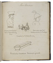
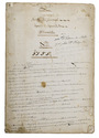
Cartographic manuscript to teach engineer-geographers to "centrer" (bisect?) angles and triangulate,
based on the work of two important French 18th-century cartographers

[MANUSCRIPT - CARTOGRAPHY]. 
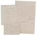
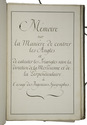
Memoire sur la manière de centrer les angles et de calculer les triangles selon la direction de la méridienne et de la perpendiculaire à l 'usage des ingenieurs-géographes.
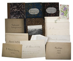
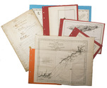
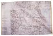
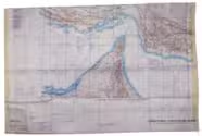
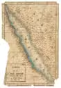
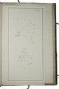
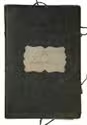
[France, ca. 1750/99]. Folio. Manuscript in French on thick paper, written in a neat 18th-century cursive hand. With 5 manuscript plates, showing 14 geometrical figures. Sewn in quires and stored loose in a portfolio covered with grey paper, grey cloth ties, paper label on the front board. [2 blank], [1], [1 blank], 61, [3 blank] pp. Full description
€ 2,750
Order Inquire Terms of sale

Travelling through Germany and Russia in the 19th century

[MANUSCRIPT - DUTCH]. TROMP, C.H. [Collection of an illustrated manuscript diary, and travel journals, including some views and photographs of Russia and Germany].
[The Netherlands, 1824-1911]. Manuscript on paper in Dutch. Preserved in a card-board box (27 x 23.5 x 7 cm), covered with marbled paper. Full description
€ 3,500
Order Inquire Terms of sale

Two signed autograph letters and a note by one of the most famous explorers
of the first half of the 19th century

[MANUSCRIPT LETTERS]. DUMONT D'URVILLE, Jules Sébastien César. [Autograph letter from Dumont D'Urville to Pierre Adolphe Lesson].
Paris, 19 September 1829. 13 x 10.2 cm.
With:
(2) DUMONT D'URVILLE, Jules Sébastien César. [Autograph letter from Dumont D'Urville to Mr. Rousset].
Paris, 14 December 1841. 21 x 13 cm.
(3) [DUMONT D'URVILLE, Jules Sébastien César]. [Autograph note by Dumont D'Urville].
[France?, first half of the 19th century?]. 8 x 10 cm.
Written in French, in a neat early 19th century cursive in brown ink. Folded. Ad 1: [1], [2 blank], [1]; ad 2: [1], [2 blank], [1]; ad 3: [1], [1 blank] pp. Full description
€ 6,000
Order Inquire Terms of sale

One of the fullest descriptions of life in Sana'a and Turkish-occupied North Yemen

MANZONI, Renzo. El Yèmen. Tre anni nell'Arabia felice. Escursioni fatte dal Settembre 1877 al Marzo 1880.
Rome, Botta heirs, 1884. 8vo. With a frontispiece portrait, 21 plates (including 7 double-page sized; the last single-page plate included in pagination), 2 folding colour-printed maps of Yemen, folding plate of the game "abdùr", folding coloured plan of Sana'a, folding view of Sana'a, folding view of Aden, as well as numerous woodcut illustrations in the text. Contemporary half calf over marbled boards with blind-stamped spine and gold-stamped spine-title. Marbled endpapers. [8], VI, [2], 446 pp. Full description
€ 2,500
Order Inquire Terms of sale

USAF pilot's map of the Arabian Gulf

[MAP - ARABIAN GULF]. Aeronautical chart and information center. Persian Gulf | ONC-H-6/7. Operational navigation chart.
St Louis, Aeronautical chart and information center, United States Air Force, 1969. Two copies of two folding maps colour printed on both sides of a sheet of silk (103 x 78.5 cm) on a scale of ca. 1:1,000,000. The two maps (ONC-H-6 & ONC-H-7) show one continuous area. Full description
€ 2,800
Order Inquire Terms of sale

Cross-cultural mapping of the Red Sea: Bruce's chart in an early Egyptian manuscript copy

[MAP - ARABIAN PENINSULA]. BRUCE, James. Carte de la mer Rouge, relevée sur celle de James Bruce.
[Egypt, probably Cairo], 1827. Folio leaf (46 x 31.5 cm). Manuscript map in pen and ink with watercolour, with a French text on Middle Eastern hand-made paper. Full description
€ 15,000
Order Inquire Terms of sale

Abu Dhabi's Oil industry: the Israeli perspective

[MAP - ARABIAN PENINSULA OIL RESOURCES]. Neft ba-mizrah ha-tikhon. Zikaynot, shadot, tzinorot, batei zikuk. [= Oil in the Middle East. Concessions, oilfields, pipelines, refineries].
Tel Aviv, Israel Defence Forces, General Staff, [1957]. 56 x 82.5 cm. Chromolithographic map of the Arabian Peninsula, from Turkey in the north to the Indian Ocean in the south, and covering Saudi Arabia, Egypt, Israel, Palestine, Jordan, Syria, Lebanon, Iraq, Iran, Kuwait, Bahrain, Qatar, United Arab Emirates, Oman, North and South Yemen. Scale 1:5,000,000. Scale and key in Hebrew inset to top-right, inset explanatory panels in Hebrew and English, compass rose in Saudi Arabia. Folded. Full description
€ 7,500
Order Inquire Terms of sale

Asia and the Middle East in 1952, with many borders on the Arabian Peninsula still undefined

[MAP – ASIA – MIDDLE EAST]. NATIONAL GEOGRAPHIC SOCIETY. Southwest Asia, India, Pakistan, and Northeast Africa.
Washington, DC, National Geographic Society, 1952. Colour printed map, 68.5 x 95 cm. Scale 1:7,5000,000. With an inset map of "the Moslem World; percentage of Moslems in total population". Full description
€ 850
Order Inquire Terms of sale

Early 19th-century edition of a woodcut plan imaging Nagasaki and Deshima

[MAP]. BUNKINDO HAN. Hishu Nagasaki (no) zu [= plan of Nagasaki, Hizen province].
[Nagasaki, Bunkindo, 1821]. 61.5 x 87 cm. Large folding woodcut map of the port and city of Nagasaki, printed in three colours (ochre, blue and green) on four sheets. In Japanese ochre paper etui decorated with blue and white flowers and title label with Japanese characters pasted on, preserved in later dark blue cloth slipcase in Japanese style closing with two ivory clasps. Full description
€ 2,950
Order Inquire Terms of sale
679 books found / Show all