Categories
Shopping cart (0 items € 0)
Advanced search

Asia / Cartography & Exploration

The most extensive, precise and complete descriptions of Java ca. 1850, beautifully illustrated

JUNGHUHN, Franz Wilhelm. Java, zijne gedaante, zijn plantentooi en inwendige bouw. ... Tweede verbeterde uitgave.
Including: JUNGHUHN, Franz Wilhelm. Atlas van platen, bevattende elf pittoreske gezigten. − Behoorende tot het werk Java, zijne gedaante, zijn plantentooi en inwendige bouw.
Den Haag, C.W. Mieling, 1853-1854. 4 text volumes and 1 plates volume. Large 8vo (26 x 17.5 cm: text volumes 1-4) and large folio (44 x 31.5 cm: plates volume). Each text volume with a lithographic title-page, vol. 1 with the text blue on white and vols. 2-4 with the text white on buff; the plates volume with a double-page letterpress title-page. Further with 12 double-page chromolithographed or double-tinted lithographed views: 1 as frontispiece to vol. 1 and 11 (43 x 58 cm; image 31 x 43 cm to 38 x 54 cm, 5 numbered VII, VIII, X, XI & XV) in the atlas volume; most in black, buff and blue and at least most drawn by Junghuhn and lithographed by Mieling (all but the frontispiece signed by the latter), and 51 black and white lithographic plates (45 folding) with topographic maps, views, cross-sections, etc. Contemporary half red sheepskin(?), (text vols.) and goatskin morocco (atlas vol.), gold-tooled spines. Bound by Hendrik Willem Ywema (1828-1905) in Utrecht. 16, VIII, 17-671; XII, 538; 539-1432; VIII, 498 pp. plus title-pages & plates. Full description
€ 32,500
Order Inquire Terms of sale

A geological description of Java

JUNGHUHN, Friedrich Franz Wilhelm. Terugreis van Java naar Europa, met de zoogenaamde Engelse overlandpost, in de maanden september en october, 1848.
Zaltbommel, Johannes Noman and son, 1851. 8vo. With 6 lithographed plates (2 folding, including 4 chromo-lithographed views). Modern half cloth. [6], 127, [3] pp. Full description
€ 475
Order Inquire Terms of sale

The main source of early knowledge of the Pelew or Palau Islands in Micronesia, in Dutch translation

KEATE, George. Beschryving van de Pelew Eilanden ...
Rotterdam, Gerard Abraham Arrenberg, 1789. 4to. With 8 plates: 4 mixed technique (partly stipple-engraved) portraits, 1 large folding engraved map of the Palau Islands and western equatorial Pacific, and 3 folding engraved views. Contemporary boards. XXXII, 365, [1] pp. Full description
€ 2,500
Order Inquire Terms of sale

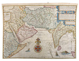
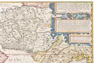
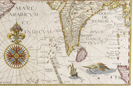
World atlas including one 6-sheet and eleven 4-sheet wall maps

KITCHIN, Thomas and others. Kitchin's general atlas, describing the whole universe.
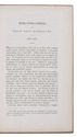
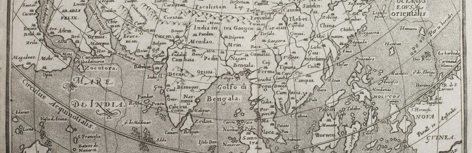
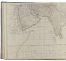
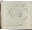
London, Robert Laurie, James Whittle, 1808. Imperial folio (53 x 39.5 cm). With 28 engraved maps (numbered in 41 parts) assembled from 67 sheets. Most include elaborate cartouches with pictorial decoration. With the maps coloured in outline. Contemporary half calf. 1 leaf plus maps. Full description
€ 18,000
Order Inquire Terms of sale

Travels through the Middle East, India and Europe, with 34 woodcut illustrations, including several trees

LA BOULLAYE LE GOUZ, Francois de. Les voyages et observations du sieur de la Boullaye-le-Gouz gentil-homme Angevin...
Paris, Francois Clousier, 1653. 4to. With a woodcut and an engraved author's portrait, 34 woodcut illustrations in text, including several full-page, and some woodcut initals, head- and tailpieces. Contemporary calf, gold-tooled spine. [16], 540, [10], [2 blank] pp. Full description
€ 18,000
Order Inquire Terms of sale

First edition of a voyage to India

LA FLOTTE, M. de. Essais historiques sur l'Inde, précédés d'un journal de voyages et d'une description géographique de la Côte de Coromandel.
Paris, Herissant, 1769. 12mo. With 3 full-page engraved plates. Contemporary calf, spine gilt. [4], 360, [12] pp. Full description
€ 600
Order Inquire Terms of sale

Dutch edition of a detailed account of an important circumnavigation

LAPLACE, Cyrille Pière Théodore. Reis rondom de wereld door de zeeën van Indië en China; . . .
Zaltbommel, Johannes Noman and sons, 1834-1836. 7 volumes bound as 3. 8vo. Each volume with a lithographed title-page, each with a different topographic view, folding engraved map tracking Laplace's journey, 13 lithographed plates (7 folding). Near contemporary uniform blue-black half calf, gold- and blind-tooled spines. XXXVI, 511, [1]; [II], 328; [II], 272; [II], 288; IV, 272; [II], 262, [1], [1 blank]; IV, 323, [1] pp. Full description
€ 2,750
Order Inquire Terms of sale

Important scientific and trade voyage around the world

LAPLACE, Cyrille Pierre Théodore. Voyage autour du monde par les mers de l'Inde et de Chine ... exécuté sur la corvette de l'état La Favorite pendant les années 1830, 1831 et 1832.
Paris, Imprimerie Royale (views volume: Arthus Bertrand; map volume: Dépôt-Générale de la Marine), 1833-1835. 4 text volumes (8vo), 1 views volume (folio) and 1 atlas volume (1mo, 66 x 51 cm). With 1 folding engraved map in the first text volume, 2 full-page maps and 10 maps on 9 double-page plates in the "atlas hydrographique", and 72 extraordinary aquatint plates (ca. 27 x 36 cm) in the "album historique", most of them with the blind-stamped image of the ship La Favorite (15 x 28 mm). Contemporary half dark green calf, gold-tooled spines. [4], XLI, 558, [2]; [4], 481, [1]; [4], 510, [2]; [4], 480; [4] pp. Full description
€ 69,500
Order Inquire Terms of sale

Illustrated eye-witness accounts and tall tales: sixty years of a sailor's world travels

LE BLANC, Vincent. De vermaarde reizen van de heer Vincent Le Blanc van Marsilien, die hy sedert d'ouderdom van veertien jaren, tot aan die van zestig, in de vier delen des werrelts gedaan heeft ...
Amsterdam, Jan Hendricksz. Boom, Jan Rieuwertsz., 1654. 2 parts in 1 volume. 4to. With engraved title-page and 7 engraved plates. 19th-century boards. [1], [1 blank], 152, 116 pp. Full description
€ 4,500
Order Inquire Terms of sale
168 books found / Show all