Categories
Shopping cart (0 items € 0)
Advanced search

Asia / Cartography & Exploration

Account of the Japanese Empire, especially in the 1850s

POMPE VAN MEERDERVOORT, Johan Lidius Cathrinus. Vijf jaren in Japan. (1857-1863.) Bijdragen tot de kennis van het Japansche Keizerrijk en zijne bevolking. ...
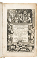
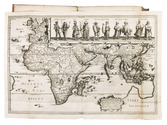
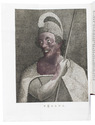
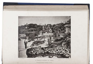
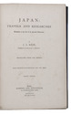
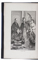
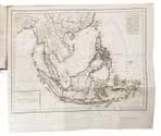
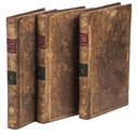
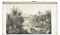
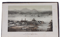
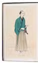
Leiden, Van den Heuvel and Van Santen, 1867-1868. 2 volumes. 8vo. Each volume with a different double-tinted lithographed view as frontispiece, further with a large folding tinted lithographed map of Japan and the Chinese coast, 2 lithographed views and 10 chromolithographed costume plates by P.W.M. Trap (the chromolithographs finished by hand). Original publisher's blind- and gold-blocked maroon cloth, marbled edges, green ribbon markers. XII, 335, [1]; VI, 357, [1] pp. Full description
€ 5,000
Order Inquire Terms of sale

The first English voyage to Hawaii after Captain James Cook's

PORTLOCK, Nathaniel. Reis naar de noord-west kust van Amerika. Gedaan in de jaren 1785, 1786, 1787 en 1788.
Amsterdam, Matthijs Schalekamp, 1795. 4to. With folding engraved map (34.5 x 46 cm) showing the routes of the ships King George and Queen Charlotte, 1 plate with engraved music and 8 folding engraved plates (last plate partly hand-coloured). Modern red half leather. XII, [4], 265, [1] pp. Full description
€ 2,750
Order Inquire Terms of sale

Ichthyology of western China

PRZEWALSKI, Nicolai Michailovich. Wissenschaftliche Resultate der von N.M. Przewalski nach Central-Asien unternommenen Reisen auf Kosten einer von seiner Kaiserlichen Hoheit dem Grossfürsten Thronfolger Nikolai Alexandrowitsch gespendeten Summe herausgegeben von der Kaiserlichen Akademie der Wissenschaften. Zoologischer Theil. Band III, Abth. 2. Fische. Bearbeitet von S. Herzenstein. Lieferung 1[-3].
St. Petersburg, for the Royal Academie of Science, 1888-1891. 3 parts in 1 volume. Folio. With 3 title-pages, recto printed in cyrillic, verso in German, and 25 lithographed plates by R. and I. (or J.) Koch, and several illustrations in text. Later cloth. [2], VI, 91, [1]; 91-180; 181-262 pp. Full description
€ 1,950
Order Inquire Terms of sale

One of the earliest maps of Arabia, with unique contemporary illumination

[MAP - ARABIAN PENINSULA]. PTOLEMAEUS, Claudius. [Jacobus ANGELUS, trans.; Nicolaus GERMANUS, ed.]. Sexta Asie Tabula.
Ulm, Lienhart Holle, 1482. Oblong 1mo (whole sheet: 41.5 by 57 cm). With a double-page woodcut map. Finely coloured by a contemporary hand, with near-contemporary manuscript vignette illustrations of an Ababeel bird, Makkah (Mecca) and the Kaaba in pen and wash highlighted in gold. Full description
€ 150,000
Order Inquire Terms of sale

Second map of the Arabian peninsula ever published

[MAP - ARABIAN PENINSULA]. PTOLEMAEUS, Claudius. Sexta Asiae tabula.
[Rome, Petrus de Turre, 1490 (engraved Rome, ca. 1478)]. Engraved map of the Arabian peninsula (topographic image 25.5 x 46 cm) printed, as usual, on two joined folio leaves (together 39.5 x 56 cm). Mounted on paper board, in a modern gilt frame (50.5 x 67 cm). Full description
€ 50,000
Order Inquire Terms of sale

Brief and complete history of Japan

REIN, Johannes Justus. Japan: travels and researches. Undertaken at the cost of the Prussian government. ... Translated from the German. With twenty illustrations and two maps.
London, Hodder and Stoughton (back of title-page: Butler & Tanner, The Selwood printing Works, Frome, and London.), 1888. 8vo. With 8 wood engraved plates, 3 lithographed maps, 4 small engravings in text and 5 black and white phototypes and 2 tinted, lithographed folding maps. Modern half morocco. X, [2], 543, [1 blank], [2] pp. Full description
€ 650
Order Inquire Terms of sale

A French voyage to the Far East, presentation copy

RENOUARD DE SAINTE-CROIX, Felix. Voyage commercial et politique aux Indes Orientales, aux Iles Philippines, a la Chine, avec des notions sur la Cochinchine et le Tonquin, pendant les années 1803, 1804, 1805, 1806 et 1807.
Paris, Clament frères (printed by Crapelet), 1810. 3 volumes. 8vo. With 2 folding engraved maps (India and Southeast Asia, coloured in outline), and 4 folding letterpress tables. Contemporary gold-tooled tree calf. X, 301, [1]; [4], 390; [4], 291, [1] pp. Full description
€ 7,500
Order Inquire Terms of sale

The state of religion in the Dutch East Indies

RHIJN, Leonard Johannes van. Reis door den Indischen Archipel, in het belang der evangelische zending.
Rotterdam, M. Wijt & zonen, 1851. 8vo. With 1 chromolithographed and 4 lithographed folding maps and 8 tinted lithographed illustrations. Rebacked in modern half cloth and the original gold-tooled green sheepskin backstrip laid down. XX, IV, “655” [= 651], 28 pp. Full description
€ 1,500
Order Inquire Terms of sale

One of the first scientific descriptions of Gorontalo

ROSENBERG, Carl Benjamin Hermann von. Reistogten in de afdeeling Gorontalo, gedaan op last der Nederlandsch Indische regering.
Amsterdam, Frederik Muller, 1865. 8vo. With 4 folding lithographed maps (3 chromo, 1 tinted), 9 full-page lithographed plates (4 chromo, 5 tinted (of which 2 folding)). 20th-century cloth. VIII [i.e. VI], 162 [1, 1 blank] pp. Full description
€ 450
Order Inquire Terms of sale

A compendium for sailing the Indian Ocean, with three charts, second copy located

ROSSER, William Henry. Short notes on the winds, weather, & currents, together with general sailing directions and remarks on making passages; to accompany a chart of the Indian Ocean. With two[=three] illustrations.
London, James Imray and son, 1866. 8vo. With 3 folding lithographed charts (the first as frontispiece and the third possibly extra added). Modern brown cloth, spine with a long vertical leather title-label. [4], 64 pp. Full description
€ 3,500
Order Inquire Terms of sale
169 books found / Show all