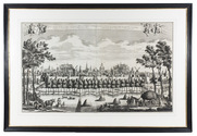
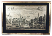
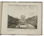
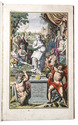
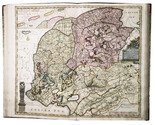
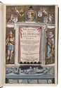
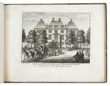
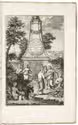
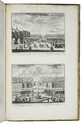
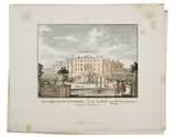
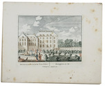
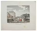
Categories
Shopping cart (0 items € 0)
Advanced search

Low Countries / Cartography & Topography

“The Versailles of the Achterhoek”

SCHENK, Pieter. Delineatio domus recreatricis adjacentiumq[ue] prospectuum amoenissimorum extra urbem Zutphaniensem, auspicys & jussu ... Arnoldi Justi ...
Amsterdam, Pieter Schenk, [1702 or ca. 1720]. Oblong 4to (21 x 27 cm). With an engraved title-page and 16 numbered engraved views (ca. 15 x 19 cm), each with a caption in Dutch and Latin below the border, mostly in two lines. 19th-century grey-brown paste-paper with a wave pattern over boards. [1], 16, [1 blank] engraved ll. Full description
€ 2,750
Order Inquire Terms of sale

Expanded and illustrated second edition of a classic description of Friesland

[SCHOTANUS, Christiaan]. Beschryvinge van de heerlyckheydt van Frieslandt tusschen 't Flie end de Lauwers.
[Franeker], Johannes Wellens, [1664]. Folio. With engraved title-page, full-page engraved coat of arms of the province of Friesland, and 46 engraved maps and plans (4 large folding maps, 31 double-page maps and 11 double-page city plans) by Jacob van Meurs after Bernardus Schotanus à Sterringa. Contemporary blind-tooled vellum. [8], 280, [1], [1 blank] pp. Full description
€ 5,000
Order Inquire Terms of sale

Spectacular atlas of Friesland, beautifully coloured by a contemporary hand

SCHOTANUS VAN STERRINGA, Bernhard. Uitbeelding der heerlijkheit Friesland; zoo in 't algemeen, als in haare XXX bijzondere grietenijen; ... Nu nieuwelijks met bijgevoegde aangrenzingen, en veel vermeerderingen: nevens d'afteekening van Oud Friesland,...
[Leeuwarden], François Halma, 1718. Imperial folio (54.5 x 33 cm). With an engraved allegorical title-page; 3 full-page engraved heraldic plates; and 37 double-page and 2 larger folding engraved maps. Beautiful cartouches and landscapes on all maps, mostly by Jan and Caspar Luyken, all beautifully coloured by a contemporary hand. Contemporary red half roan, later cloth corners and reinforcing. [4] pp. plus plates. Full description
€ 12,500
Order Inquire Terms of sale

Classic history and description of Gelderland with maps in a contemporary hand-colouring,
bound by the Utrecht "Vase Block Bindery"

SLICHTENHORST, Arend van. XIV. Boeken van de Geldersse Geschiedenissen, van 't begin af vervolghd tot aen de afzweeringh des Konincx van Spanien; ...
Arnhem, Jacob van Biesen, 1654. 2 parts in 1 volume. Folio. With an engraved title page, a letterpress half-title, a large folding engraved map, 20 double-page plans and maps, 28 woodcut coats of arms in the text, as well as woodcut medals, and letterpress genealogical tables. With exception of some medals all plates and illustrations are coloured by a contemporary hand and partly highlighted with gold. Early 18th-century gold-tooled mottled calf by the so-called "Vase Block Bindery". [16], 116, [4]; 596, [24] pp. Full description
€ 25,000
Order Inquire Terms of sale

The Seventeen Provinces: a detailed map with additional views of major cities
and examples of local dress

SPEED, John [and Pieter van der KEERE?]. A new mape of ye XVII provinces of Low Germanie.
[London], George Humble, 1626. 41 x 53 cm. Engraved map with hand coloured borders, probably by Pieter van den Keere (1571-after 1646). Incorporating a fine compass-rose with 32 rhumb lines and names of the wind-directions, a coat of arms of France, a title-cartouche, a legend ("A catalogue of the cities et [!] villages in everie Province") and an indication of scale (ca. 1:1.120.000). The map is topped by 8 hand coloured miniature profiles of major cities and bordered by hand coloured figures in local costume at the left (5 male figures) and right (5 female figures). Framed. Full description
€ 4,000
Order Inquire Terms of sale

Very rare large bird's eye view of the Zeist House and gardens, surrounded by similar print series

STOOPENDAAL, Daniel. Veue de la maison de Zeyst avec ses jardins et plantages appartenans à Monsieur Le Comte de Nassau - Het Gezigt van het Huys van Zeyst, met zyn tuynen en plantagien, toebehoorende aan Myn Heer De Graaf van Nassau.
With: STOOPENDAAL, Daniel. [Twenty views of Zeist House and Garden].
Amsterdam, Nicolaus Visscher, [ca. 1700]. Large engraved view (ca. 62 x 87 cm) surrounded by a series of 20 engraved plans and views (each. ca. 16 x 21 cm) all by Daniel Stoopendaal. Framed (ca. 118 x 106 cm). Full description
€ 19,500
Order Inquire Terms of sale

Print series with beautiful views of one of the most prestigeous country houses and gardens
of the Dutch Republic

STOOPENDAAL, Daniel and Laurens SCHERM. Verscheyde schoone en vermaakelyke gezigten, in de Hofstede van Clingendaal gelegen by 's Gravenhage.
[Amsterdam], Nicolaas Visscher, [ca. 1697/1701]. Small oblong folio (18 x 24 cm). With 32 numbered engraved prints (13 x 16.5 cm), including the title-page, captioned in Dutch, with views of the country house and gardens of Clingendaal near The Hague, designed and etched and engraved by Daniel Stoopendaal, Laurens Scherm and Leon Schenk. Blind- or black-tooled half calf (ca. 1900), marbled paper sides and endpapers. [32] engraved ll. Full description
€ 2,950
Order Inquire Terms of sale

98 lovely engravings of the Vecht region by Stoopendaal

[STOOPENDAAL, Daniël and Andries de LETH]. De zegepraalende Vecht, vertoonende verscheidene gesichten van lustplaatsen, heeren huysen en dorpen; beginnende van Uitrecht en met Muyden besluytende.
Including: [BRUIN, Claas]. Speelreis langs de Vechtstroom, op de uitgegeevenen gezichten van de zeegepraalende Vecht.
Amsterdam, Widow of Nicolaus Visscher, 1719. 2 parts in 1 volume. Folio. With engraved frontispiece, 1 engraved map of the river Vecht and 102 engravings on 51 leaves (numbered 1-98). Contemporary red half sheepskin. [2], 16, 37, [1 blank] pp Full description
€ 2,000
Order Inquire Terms of sale

Very rare first edition of a very interesting early 19th-centure travel guide for The Netherlands

[TRAVEL GUIDE - THE NETHERLANDS]. Le voyageur dans les Pays-Bas Unis. Ouvrage indispensable pour chacun qui voyage dans ces Pays. Orné de 28 cartes, plans, vues, etc.
Amsterdam, Evert Maaskamp, 1815. 12mo. With a title vignette showing the Amsterdam publishing house of Evert Maaskamp, 3 folding maps, 13 double-page maps by I.B.D.B., 3 double-page city plans of Amsterdam, the Hague and Rotterdam, 6 full-page plates of the coins in use in The Netherlands on 1 folding leaf and 2 full-page plates of the ground floor of the Amsterdam city hall and Paleis Het Loo; all coloured by a contemporary hand. Original publisher's blue paper wrappers over boards. [2], 380, XXII, [10] pp. Full description
€ 1,850
Order Inquire Terms of sale

Spectacular views of Nieuwburg castle at Rijswijk in 1697, with an extra plate

[VIANEN, Jan van (illustrator)]. Le château Roial de Ryswick appellée de Neubourg avec les differens apartemens ou se tiennent les conferences de la paix generale.- Het koninklyke kasteel tot Ryswyck. Genaamt Nieuwburg, met alles des selfs kamers en gezigten, in 't bysonder, daar de conferentien der algemeene vreede gehouden werden, &c.
The Hague, Anna Beek, [1697]. Folio (33 x 20.5 cm). With a double-page title in red and black, 13 double-page engraved views (ca. 22 x 27 cm) on guards of Nieuwburg castle, 12 of which signed by Jan van Vianen. Contemporary quarter red sheepskin, marbled paper sides. [14] double-page ll. Full description
€ 5,950
Order Inquire Terms of sale
68 books found / Show all
Recently viewed