Categories
Shopping cart (0 items € 0)
Advanced search

Low Countries / Cartography & Topography

Rare wall map of the Gooi, coloured by a contemporary hand

[MAP - HET GOOI]. POST, Hendrik. Nieuwe kaart van Gooilandt word met schuldige eerbiedigheidt aan den wel. ed. gestr. Heere en Mr. Henrick Bicker schepen der stadt Amsterdam, raadt en advt. fiscaal ter Admiraliteit aldaar meestersknaap van Gooilandt, enz, enz. opgedragen door Reinier & Josua Ottens.
Amsterdam, Reinier & Josua Ottens. [ca. 1737]. 52.5 x 82 cm. Framed. Full description
€ 28,000
Order Inquire Terms of sale

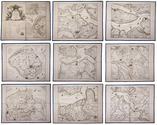
Collection of 6 maps of the Beemster polder 1644-1979

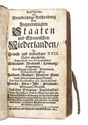
[MAP - NETHERLANDS - BEEMSTER]. FLORISZ. VAN BERCKENRODE, Balthasar and Daniel van BREEN. 
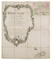
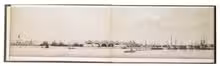
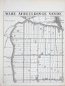
Beemsterlants caerte... [with a second title at the head:] Ware afbeeldinge vande bedyckte Beemster-landen... M.DC.XLIIII.
Amsterdam, 1644 [reprinted ca. 1769?].
And:
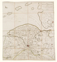
(2) [FLORISZ. VAN BERCKENRODE, Balthasar] and Daniel van BREEN. Beemsterlants caerte...
Amsterdam, 1658. Engraved map (43.5 x 58 cm).
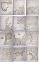
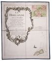
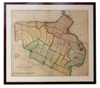
(3) [MAP - NETHERLANDS - BEEMSTER]. Beemster landts kaarte, aenwijsende de hoogte vande ringhdyck. Als mede de diepte vande tocht & wech slooten.
[Amsterdam(?), ca. 1696].
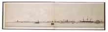
(4-5) DORLAND, C. [2 maps of the Beemster].
Amsterdam, Tresling & Co., March 1908.
(6) [MAP - NETHERLANDS - BEEMSTER]. Waterschap de Beemster.
February 1970, updated to 1979. Large map (64 x 50 cm).
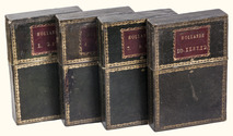
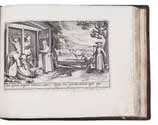
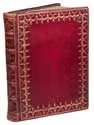
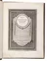
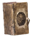
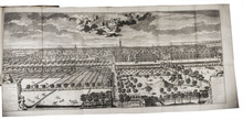
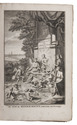
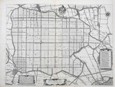
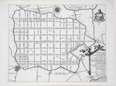
Collection of 6 maps (the first in 6 sheets). Engraved map in 6 sheets (each 56 x 44 cm). With the main title in a large cartouche at right, the statement about its production and a scale of Rijnland rods in a pedestal at the foot, a Latin verse in praise of the Beemster polder by Caspar van Baerle at lower right, a compass rose at upper right, and the arms of Beemster at the head. Bound in modern cloth (57.5 x 47 cm). Full description
€ 3,750
Order Inquire Terms of sale

Rare 18th-century wall map of the Netherlands

[MAP - NETHERLANDS]. [LE ROUGE, George-Louis]. La Hollande en 12 feuilles.
Paris, Jean Dezauche, 1790. Published on 12 sheets, numbered as 48 quarter-sheets. An engraved wall map of the Netherlands (excluding Zeeland), with the main title in a large cartouche at upper left, the Latin title at upper right. Many cities and coastlines, and a few other features, highlighted in colour. Cut, mounted on cloth and folded, in 4 contemporary gold-tooled green morocco boxes. Full description
€ 8,500
Order Inquire Terms of sale

Two large wall maps of the Dutch provinces, from the library of Marco-Antonio III (1730-1800), Prince Borghese

[MAPS - NETHERLANDS]. [LE ROUGE, George-Louis]. La Hollande en 12 feuilles dont les six premieres contiennent la Hollande ...
Paris, Jean A. Dezauche, successor of Delisle & Buache, 1790. Together ca. 230 x 155 cm. Engraved map, hand-coloured in outline. Printed on 12 sheets, each divided into 4 segments, numbered 1-48. The 12 sheets are mounted on contemporary linen and folded, the edges reinforced with blue ribbon.
With: (2) LE ROUGE, George Louis. Topographie de la Zelande en 9 feuilles traduitte de l'Hollandois. [Second title:] Partie orientale de la Flandre Hollandoise, ...
Paris, Jean A. Dezauche, 1790. Large engraved wall map, hand-coloured in outline, printed on 9 numbered sheets, each divided into 4 segments, numbered 1-36 (each sheet 48 x 56.5 cm); the 36 segments are mounted on contemporary linen, the edges reinforced with blue ribbon. Each map in contemporary box. Full description
€ 8,950
Order Inquire Terms of sale

Most complete copy of 1618 edition seen, with 8 armorial plates and 30 views

MARCUS, Jacobus. Deliciae Batavicae[.]...
Amsterdam, Johannes Janssonius, 1618. Oblong 8vo (text) & small oblong 4to (plates) (14.5 x 19 cm). With 8 engraved armorial plates. These are followed by 30 engraved views or scenes most with a Latin distich at the foot. Interleaved. Sprinkled calf (ca. 1700), gold-tooled spine. [1], [1 blank], [5], [1 blank] pp. plus plates. Full description
€ 12,500
Order Inquire Terms of sale

Topographical wall map of the Dutch (polder) district Vijfheerenlanden, coloured by a contemporary hand

OTTENS, Reinier and Josua OTTENS. Nieuwe kaart van de Vyf Heeren landen gelegen tusschen den Dief en Zouwen dyk.
Amsterdam, Reinier and Josua Ottens, 1741. Engraved map on 4 sheets (85 x 98 cm as assembled), coloured by a contemporary hand. With the title and publisher at the foot left, together with a scale (ca. 1:19,000) and the name of the engraver at the right (Jan van Jagen). Framed. Full description
€ 6,000
Order Inquire Terms of sale

Amsterdam unfolded: a panorama of the city as seen from the IJ

[PANORAMA - AMSTERDAM]. Johan Conrad GREIVE jr. (illustrator). Panorama dAmsterdam.
[Amsterdam], [printed by R. de Vries for] François Buffa & Sons, [ca. 1860]. Oblong (ca.16.4 x 24.6 cm. per leaf). The panorama is made up of 8 numbered lithographed views, printed in monochrome with beige tone block. The viewer looks southward from the IJ over the city from the Oosterdok (eastern dock) and the Oosterkerk (eastern church) along the docks and wharfs, via the recognisable towers of several churches and the view of the Royal Palace, to the Westerdok (western dock), a large factory, and the Blauwhoofd, the northwestern-most bulwark of the city. Original brown blind-stamped wave-grained cloth with the title and imprint information lettered in gold on the front board in a rococo frame, yellow endpapers. 8 numbered views folded making 24 pages. Full description
€ 3,750
Order Inquire Terms of sale

First edition of the first extensive history of Gelre

PONTANUS, Johannes Isaac. Historiae Gelricae libri XIV. ...
Harderwijk and Amsterdam, Nicolaes van Wieringen and Johannes Janssonius, 1639. Folio. With a richly engraved title, a full-page engraved portrait of the author by J. van Velde, 5 double-page engraved maps of Gelderland, 4 double-page engraved plans of Nijmegen, Arnhem, Zutphen and Harderwijk, all with a view in profile at the top, and 3 full-page engraved portraits. Contemporary blind-tooled vellum. [26], 72, 956, [72] pp. Full description
€ 3,250
Order Inquire Terms of sale

Beautiful views of castles, ruins, monasteries, villages and towns of the Dutch Republic

RADEMAKER, Abraham. Kabinet van Nederlandsche en Kleefsche outheden.
Amsterdam, Isaak Tirion, [between 1728 and 1766]. 2 parts in 1 volume. 4to. With an engraved title page in each part, and 300 numbered engraved half-page views. Contemporary gold-tooled red morocco. [76]; [76] ll. Full description
€ 3,500
Order Inquire Terms of sale

The Low Countries: a geographical and historical description in German,
fitting in the publishing programme of the firm of Christoph Riegel in Frankfurt am Main

[RIEGEL, Christoph]. Ausführliche und grundrichtige Beschreibung der freyvereinigten Staaten und Spannischen Niederlanden, in gewisse und sonderbare XVII. Länder abgetheilet ...
Frankfurt am Main and Leipzig, Christoph Riegel, 1691. 12mo. With a folding engraved frontispiece, 61 full-page engraved plans, and 59 full-page engraved views of the cities and fortifications of the Low Countries. Contemporary vellum with an oval supralibros mounted in the centre of both boards, red edges, leather closing ties. [8], 1078, [8] pp. + 120 engravings. Full description
€ 2,500
Order Inquire Terms of sale
71 books found / Show all