
An Arabist advocating archaeological research of the Near East
MANGER, Samuel Hendrik.
Oratio inauguralis, de incremento philologiae sacrae ab idonea Arabiae atque Palaestinae exploratione sperando.
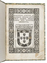
Franeker, Willem Coulon, 1762. Folio. With the woodcut coat of arms of Friesland on the title-page. Mid-19th-century marbled wrappers. [4], 67, [1 blank] pp. Full description
€ 1,250
Franeker, Willem Coulon, 1762. Folio. With the woodcut coat of arms of Friesland on the title-page. Mid-19th-century marbled wrappers. [4], 67, [1 blank] pp. Full description