Categories
Shopping cart (0 items € 0)
Advanced search

Cartography, Exploration & Voyages

Early 18th-century guide to Amsterdam

[AMSTERDAM - CITY GUIDE]. 
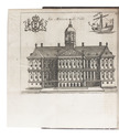
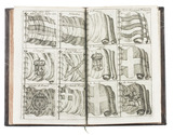
Le guide ou nouvelle description d'Amsterdam, enseignant aux voyageurs, et aux negoçians sa splendeur, son commerce, & la description de ses edifices, ruës, ports, canaux, ponts, ecluses, &c. Nouvelle edition augmentée considerablement.
Amsterdam, Paul de la Feuille, 1720.
With: (2) Tarif general des Provinces Unies pour les droits d'entrée & de sortie que payent les marchandises, tant en ce païs qu'à la Mer Baltique, au passage du Sont.
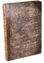
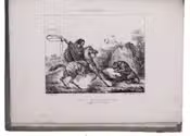
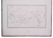
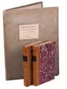
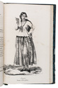
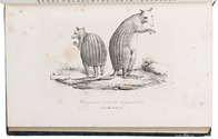
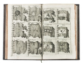
Amsterdam, Paul de la Feuille, 1718. 2 works in 1 volume. 8vo. Ad 1 with 28 engraved illustrations on 24 folding leaves. Further with a small woodcut vignette on the title page, one woodcut decorated initial, and one woodcut headpiece. Ad 2 with a woodcut floral vignette on the title page, and typographical tables in the text. Contemporary gold-tooled mottled calf, with a red morocco title label lettered in gold on the spine, gold-tooled board edges, and red sprinkled edges. [1], [1 blank], [4], "216" [= 198], [2 blank]; 123; [2]; pp. Full description
€ 1,250
Order Inquire Terms of sale

Private photographs of a visit to the oilfields of the APOC, by the founder of Toc H

[ANGLO-PERSIAN OIL COMPANY - PHOTOGRAPHS]. [CHAPPELL, Henry Pegg (photographer)]. A Christmas pilgrimage to the Anglo-Persian Oil Co. in Persia made by P.B.C.. S.C.. H.P.C.
[Greece, Palestine, Iran, Iraq, Egypt, 1931-1932]. Oblong photograph album (20.5 x 32 cm). With 72 sepia photographs (ca. 6 x 8.5 cm). [19], [5 blank] ll. Full description
€ 8,500
Order Inquire Terms of sale

The first and “most sought after” edition of the most popular maritime travel account of the 18th century

ANSON, George and Richard WALTER and/or Benjamin ROBINS (ed.). A voyage round the world, in the years MDCCXL, I, II, III, IV.
London, printed for the author, by John and Paul Knapton, 1748. Large 4to. With 42 engraved plates, maps and plans, all but one folding. Bound by Marcus Ward & Co. (founded 1833), with their bookbinder's label on the front paste-down, in 19th-century calf, gold-tooled and blind-tooled frame on both boards, gold-tooled spine with red morocco spine label with title in gold, gold-tooled board edges, blind-tooled turn-ins, red edges, blue ribbon marker. [1], [1 blank], [32], [1 blank], 417, [1 blank], [2] pp. Full description
€ 6,500
Order Inquire Terms of sale

Magnificent eighteenth-century atlas of the world, with 30 beautiful maps.

ANVILLE, Jean Baptiste Bourguignon d'. [Atlas Général].
[Paris, "chez l'auteur aux Galleries du Louvre", 1743-1771]. Large folio (54.5 x 40.5 cm). Atlas comprising 30 maps of the world, most of them engraved by Guillaume de la Haye, (in 2 full-page, 23 double-page, and 21 folding; about 10 maps measuring ca. 100 x 100 cm when put together). Numbers 1-8 and 9-33 have a coloured in outline. Contemporary three-quarter calf, boards covered with marbled paper. Without printed title (not always present), but with manuscript index on the recto of the first flyleaf. Full description
€ 27,500
Order Inquire Terms of sale

A large two-sheet map of the Middle East

ANVILLE, Jean Baptiste Bourguignon d'. Premier Partie de la Carte d' Asie, contenant La Turquie, L'Arabie, La Perse, L'Inde en deça du Gange et de la Tartarie ce qui est limitrophe de la Pers et du Gange.
Paris, 1751 Engraved map on two sheets (75 x 79 cm), with hand-coloured cartouche and coloured in outline. Full description
€ 950
Order Inquire Terms of sale

Extensively illustrated classic of cosmography, geodesy, mensuration, perspective and optics

APIANUS (APIAN), Petrus and Gemma FRISIUS. Cosmographia.
Antwerp, Jan Verwithagen (colophon: printed by Verwithagen), 1574. 4to. With a large woodcut on the title-page (with a terrestrial globe and other instruments); 4 printed paper volvelles with moving parts and a woodcut sun dial with a string attached to its centre; a folding woodcut cordiform mappa mundi (block size 19×27.5 cm) with letterpress text in the margins; well over 100 further woodcut illustrations, diagrams, maps, etc., in the text. Recased in 17th-century(?) limp sheepskin parchment. [2], 64, [2] ll. plus folding woodcut. Full description
€ 12,500
Order Inquire Terms of sale

Vivid account of an important exploration of the Pacific,
with beautiful illustrations of the scenery and inhabitants

ARAGO, Jacques Etienne Victor. Promenade autour du monde pendant les années de 1817, 1818, 1819 et 1820, sur les corvettes du Roi l'Uranie et la Physicienne, commandées par M. Freycinet.
Paris, Béthune & Plon for Leblanc, 1822. 3 volumes. 8vo (text) and folio (atlas). With 26 full-page lithographed plates (1 lithographed map of the world, and 25 views and portraits, of which 2 of Rio de Janeiro, 5 of the Sandwich Islands and 3 of Australia). The text volumes in contemporary gold- and black-tooled quarter calf; the atlas volume in contemporary grey boards. [4], XXX, 452; [4], 506 pp.; [28] ll. Full description
€ 3,500
Order Inquire Terms of sale

On the famous voyage of Captain Louis Freycinet

ARAGO, Jacques Etienne Victor. Souvenirs d'un aveugle, voyage autour du monde. Ouvrage enrichi de soixante dessins et de notes scientifiques.
Paris, Hortet and Ozanne, 1839. 4 volumes. 8vo. With 2 engraved portraits, of Jacques and François Arago, and 60 full-page lithographed plates, all after drawings by the author. Contemporary green half sheepskin, gold-tooled spines. [4], 400; [4], 423 [1 blank]; [4], 399, [1 blank]; [4], 451, [1 blank] pp. Full description
€ 1,950
Order Inquire Terms of sale

Large folding road map of Saudi Arabia

[ARAMCO]. Saudi Arabian road map.
Dammam, Al-Mutawa press company, 1973. Large folding map (60 × 90.5 cm), printed in light orange with darker purple, depicting the Kingdom of Saudi Arabia and its main roads. With on the right the title in both Arabic and English and a table with the distances from one city to another. Full description
€ 1,800
Order Inquire Terms of sale
727 books found / Show all
Recently viewed