Categories
Shopping cart (0 items € 0)
Advanced search

Americas / Cartography, Exploration, Travel & Voyages

One of the very few contemporary sources on pirates in the seventeenth century

EXQUEMELIN, Alexandre Olivier. Histoire des avanturiers qui se sont signalez dans les Indes ...
Paris, Jacques le Febvre, 1686. 4 parts in 2 volumes. 12mo. With an engraved title page in vol. 1, 3 engraved folding maps (the Caribbean, the Bay of Maracay in Venezuela, and the Isthmus of Panama), 4 engraved plates outside of collation, 5 decorated woodcut initials, 5 woodcut headpieces, and 4 woodcut tailpieces.
Contemporary gold tooled mottled brown calf. [32], 342, [22]; [6], "384"[=390], [24] pp. Full description
€ 8,500
Order Inquire Terms of sale

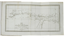
The division of Oregon Country between Britain and the United States of America
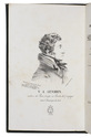
FÉDIX, P. A. L'Orégon et les côtes de l'Océan Pacifique du Nord, aperçu géographique, statistique et politique, avec une carte du pays d'après les documens les plus récens.
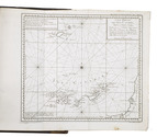
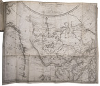
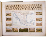
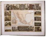
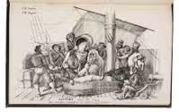
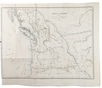
Paris, Librairie de Amyot (printed by Éd. Proux et Cie), 1846. 8vo. With a large folding map (40 x 52.5 cm) depicting what the United States called Oregon Country, dated 1846 and partly coloured in outline. Modern maroon half morocco. 258 pp. Full description
€ 9,500
Order Inquire Terms of sale

A previously unobtainable complete set of magnificent wall maps by Nicolas de Fer

FER, Nicolas de. [Set of five wall maps: America (1698), Africa (1698), Asia (1696), Europe (1695), and the World (1695)].
Paris, chez lauteur / van Loon, 1695-1698. Approximately 114 x 165 cm each. Copperplate engravings in original outline colour, tissue-backed for stability, laid down to modern cartographic linen. All with title banner dated 1698 with the Royal Privilege, and text panels dated 1703. Each map printed on four joined sheets with title surmounted and engraved text panels at sides and bottom. Full description
€ 850,000
Order Inquire Terms of sale

The North West Passage: rare Dutch translation of a journal
made on William Parrys first expedition by the ships surgeon

FISHER, Alexander (J. LEHMAN DE LEHNSFELD, transl.). Dagboek eener ontdekkingsreis naar de Noorderpoolstreken, met de schepen Zijner Grootbrittanische Majesteit Hecla en Griper, in de jaren 1819 en 1820. Uit het Engelsch naar den vierden verbeterden druk door J. Lehman de Lehnsfeld.
Dordrecht, Blussé and Van Braam, 1822. 8vo. With a folding map of the Northwest Territories or Nonavut (Canada), including the Melville Island, and 2 engravings in the text of a musk ox and an Eskimo. Modern sprinkled orange paper over thin boards with a modern spine label with printed title. [4], 364 pp. Full description
€ 1,950
Order Inquire Terms of sale

Testing chronometers by Harrison's leading French rival

FLEURIEU, Charles Pierre Claret, Count d'Eveux de. Voyage fait par ordre du Roi en 1768 et 1769, à différentes parties du monde, pour éprouver en mer les horloges marines inventées par M. Ferdinand Berthoud. Première[-seconde] partie, ...
Paris, Imprimerie Royale, 1773. 2 volumes. Large 4to (27 x 20.5 cm). With 5 numbered folding engraved plates in volume 1 (4 maps of the Atlantic Ocean, the Canaries, the Azores, etc., and 1 plate with topographic diagrams), 1 folding engraved plate with geometrical figures illustrating the determination of latitude[!], and 5 folding letterpress tables in volume 2. Contemporary gold-tooled mottled calf. [2], LXXIX, [1 blank], 803, [1 blank]; [2], 622, XL, [2 blank] pp. Full description
€ 9,500
Order Inquire Terms of sale

Collected miscellaneous writings on Cook, New Holland, Tahiti, the breadfruit tree, etc.

FORSTER, Georg. Kleine Schriften. Ein Beytrag zur Völker- und Länderkunde, Naturgeschichte und Philosophie des Lebens.
Leipzig, Paul Gotthelf Kummer [volume 1]; Berlin, Vossische Buchhandlung [volumes 2-6], 1789-1797. 6 volumes. 8vo. With 2 folding engraved maps and 20 engraved plates (2 folding). Contemporary half calf, gold-tooled spines. [12], 464; [8], 380; [6], “362” [=378]; [8], 407; [8], 435, [3]; [8], 418 pp. Full description
€ 5,000
Order Inquire Terms of sale

Letters on the celebrated voyage of "l'Uranie" by Rose de Freycinet, secretly smuggled aboard by her husband and the great explorer Louis de Freycinet

FREYCINET, Rose de (Charles DUPLOMB, ed.). Campagne de l"Uranie" (1817-1820). Journal de madame Rose de Saulces de Freycinet daprès le manuscrit original accompagné de notes par Charles Duplomb.
Paris, Société d'Éditions Géographiques, Maritimes et Coloniales (colophon: Chartres, printed by Durand), 1927. Large 4to (28.5 x 23 cm). With 1 map and 25 full-page plates, 13 colour-printed and 3 double-page (plate 7, 24 and 25), all after designs by Jacques Arago, the official artist of the voyage. Original publisher's paper wrappers. [2 blank], XIII, [1 blank], 190, [2] pp. Full description
€ 3,500
Order Inquire Terms of sale

Spanish pioneer of the use of the chronometer in navigation and mapping

GALIANO, Dionisio Alcalá. Memoria sobre las observaciones de latitud y longitud en el mar.
[Madrid], widow of Joaquin Ibarra, 1796. Narrow 4to (20.5 x 14 cm). With a woodcut crowned cypher monogram (of a Spanish Duke?) on the title-page and 7 folding leaves containing 13 numbered letterpress tables. Early 19th-century gold-tooled tree calf. [2], 87, [1] pp. Full description
€ 3,950
Order Inquire Terms of sale

The ancient habits of Mexico

GARCIA CUBAS, Antonio. The Rèpublic of Mexico in 1876. A political and ethnographical division of the population, character, habits, costumes and vocations of its inhabitants.
Mexico City, La Enseñanza, 1876. 8vo. With 8 chromolithographed plates, finished by hand, double-page map, and 4 leaves with printed music on both sides. 19th-century red morocco, gold-tooled spine, blind-tooled boards, gold-tooled turin-ins, gilt edges. 130, [12] pp. Full description
€ 950
Order Inquire Terms of sale

Mexico in the 1880s, with atlas volume including 13 chromolithographed maps and 1 general map of Mexico

GARCIA CUBAS, Antonio. Cuadro geográfico, estadístico, descriptivo é histórico de los estados unidos Mexicanos. Obra que sirve de texto al Atlas pintoresco.
Including: Atlas Pintoresco e Historico de los Estados Unidos Mexicanos.
México, Fomento & Debray, 1885. 2 volumes. 8vo and oblong large folio (64.5 x 82 cm). With 2 folding tables and 2 full-page plates in the text volume and in the atlas 13 chromolithographed maps (52 x 69 cm), and a full-page chromolithographed map of Mexico at the end. Contemporary black cloth with gold lettering on front board (text); contemporary red half morocco, title and ornaments in gold on spine (atlas). IV, 474, [3] pp. text. Full description
€ 11,000
Order Inquire Terms of sale
156 books found / Show all