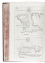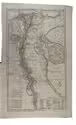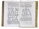

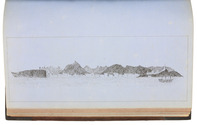
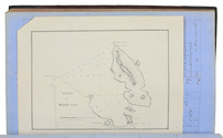
Manuscript log of a voyage from Suez through the Red and Arabian Seas to Bombay, Karachi and Colombo, with 8 excellent nautical charts and 5 beautiful sketches, including one of the city of Muscat

[OMAN NAVIGATION LOGBOOK]. MCKINNELL, Thomas, assistant master.
Log of the proceedings. HMS "Cyclops". W. J. S. Pullen Esq. Captain. Commencing Monday 7th February 1859, ending Wednesday 22nd of May, 1861. Kept by Thos. McKinnell, Mast. Asst.
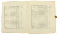
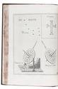
HMS Cyclops: Oman, Khuriya Muriya Islands, Yemen, Egypt, Red Sea, Arabian Sea, Pakistan, Sri Lanka and other places, 1857-1861. Folio (20 x 31.5 cm). Over 360 pp. of manuscript entries, written with brown ink in a legible hand on watermarked laid paper with a blue cast. With 8 pen and ink nautical charts and 5 sketches of coastal sites, including the city of Muscat (8 on the logbook pages and 5 on separate thick album leaves). Contemporary brown cloth over boards, rebacked in period-style black calf with the spine lettered in gold: "Log H.M.S. Cyclops". [ca. 360], [32 blank] pp. Full description
€ 45,000
HMS Cyclops: Oman, Khuriya Muriya Islands, Yemen, Egypt, Red Sea, Arabian Sea, Pakistan, Sri Lanka and other places, 1857-1861. Folio (20 x 31.5 cm). Over 360 pp. of manuscript entries, written with brown ink in a legible hand on watermarked laid paper with a blue cast. With 8 pen and ink nautical charts and 5 sketches of coastal sites, including the city of Muscat (8 on the logbook pages and 5 on separate thick album leaves). Contemporary brown cloth over boards, rebacked in period-style black calf with the spine lettered in gold: "Log H.M.S. Cyclops". [ca. 360], [32 blank] pp. Full description