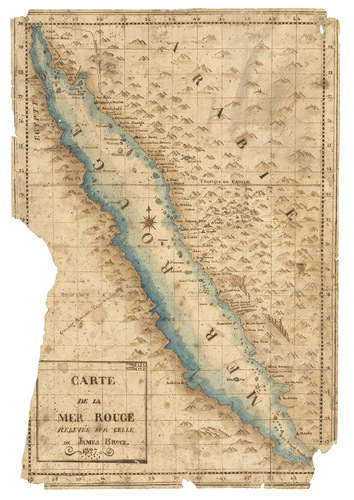
[MAP - ARABIAN PENINSULA]. BRUCE, James.
Carte de la mer Rouge, relevée sur celle de James Bruce.
[Egypt, probably Cairo], 1827. Folio leaf (46 x 31.5 cm). Manuscript map in pen and ink with watercolour, with a French text on Middle Eastern hand-made paper.
€ 15,000
A hand-drawn map of the Red Sea region of Arabia, based on a Western printed map but with compelling evidence that it originated in early 19th-century Egypt, where it was apparently prepared, and with contemporary Arabic notes on the back. While based primarily on the excellent map published in James Bruce's Travels to discover the source of the Nile (1790), with more accurate cartography than any previously available, the present manuscript, drawn on a larger scale, is an enlarged, improved detail showing only the Red Sea and its environs, revealing a particular local interest in the region during the early 19th century. The Egyptian copyist follows the coast from the Sinai Peninsula along what is today southwestern Saudi Arabia as far south as Mocha in Yemen, and includes the holy cities of Mecca and Medina. The copy bears a French title, dated 1827, in a cartouche at the lower left. A French translation of Bruce's work appeared in 1790-92, but no edition was published in 1827, which we therefore suppose to be the date of execution of the present manuscript copy.
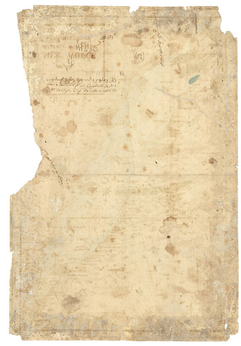
With several contemporary inscriptions in Arabic on the back, including one by Ibrahim Khwajah al-Sarraf (i.e. Ibrahim Khwajah the money changer), dated "Misr 1223" (Cairo/Egypt, 1808/09 CE), which appears to indicate that the sheet of paper was made and in use well before the map was drawn. Another inscription is signed "Sikandariyah 1244" (Alexandria 1828/29 CE), along with a religious invocation apparently including part of the genealogy of Jesus Christ from the Gospel of Matthew.
The extreme left side with a section, including one meridian, torn away; further marginal chipping, especially in the corners; several longer tears expertly restored. Otherwise in good condition. A rare document of early 19th-century Middle Eastern cartography adapted from a Western source.
Related Subjects: