[MAP - NETHERLANDS - ZEELAND]. RUYTE, Lieven.
[Walcheren ... Zuyt Bevelant].
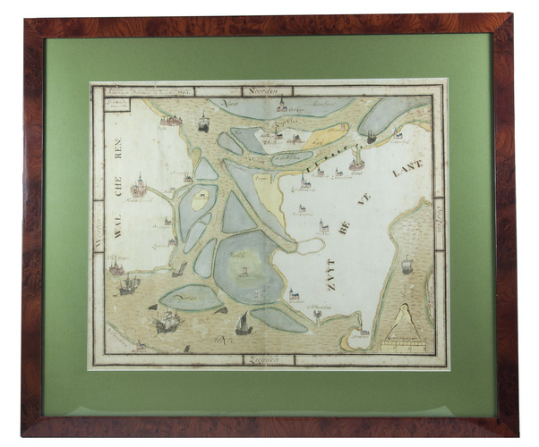
Tholen, Korstiaen Bestebroer, 1784. Map: 42 x 52.5 cm (frame: 61 x 71.5 cm). Manuscript map in ink and watercolour on paper (map image 37 x 47 cm) at a scale of about 1:55,000 with north at the top. Framed.
€ 1,900
A manuscript copy of a 1568 manuscript map of what were then islands and waterways in Zeeland, covering the eastern half of Walcheren, most of Zuid-Beveland, the southern edge of Noord-Beveland and some smaller islands. It includes the cities of Middelburg, Veere, Vlissingen and Goes, and about twenty smaller towns and villages. It is executed in pen and watercolour in subtle shades ochre, blue, yellow, grey, green and pink and represents the cities and towns pictorially (with major churches and sometimes smaller buildings and fortifications), shows roads, 7 boats and ships in the water and sandbanks.
The map was originally drawn by the surveyor Lieven Ruyte (ca. 1553-1601), apparently based on his own survey, and covers an area of about 19×27 kilometres. The original map of 1568 is said to have been in the hands of the town clerk of the city of Goes but is now known only from copies.
With some foxing, mostly in or near the margins, but otherwise in very good condition. Some minor tears are confined to the margins and the map is very slightly worn along an old vertical fold. A detailed map showing islands and waterways in Zeeland as they were in 1568. Cf. Donkersloot-de Vrij, Topografische kaarten 692; Zelandia illustrata, p. 615.
Related Subjects: