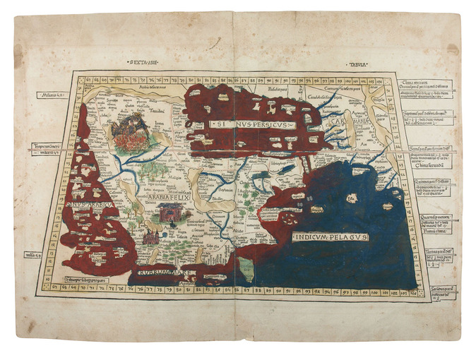
[MAP - ARABIAN PENINSULA]. PTOLEMAEUS, Claudius. [Jacobus ANGELUS, trans.; Nicolaus GERMANUS, ed.].
Sexta Asie Tabula.
Ulm, Lienhart Holle, 1482. Oblong 1mo (whole sheet: 41.5 by 57 cm). With a double-page woodcut map. Finely coloured by a contemporary hand, with near-contemporary manuscript vignette illustrations of an Ababeel bird, Makkah (Mecca) and the Kaaba in pen and wash highlighted in gold.
€ 150,000
The first map of the Arabian peninsula ever printed, from a woodcut, here finely coloured by a contemporary hand and adorned with unique, hand-drawn illumination added by a contemporary artist. The map was published in the first atlas printed outside Italy, the first atlas to be illustrated with woodcut maps. Remarkably, the hand-drawn vignette illustrations include a depiction of the relief of Makkah (Mecca), besieged by Abrahah, through the Ababeel birds, who pelted the attacking army of war elephants with burning stones from the pits of the fires of hell. The image shows a gigantic blue-and-gold Ababeel bird above the city, engulfed in flames - not only one of the earliest depictions of Makkah but also an amazing example of cross-cultural exchange of narratives during the early Renaissance, proving a Western illustrators familiarity with a Middle Eastern tradition famously referenced in the Quran (sura 105, known as al-Fil, The Elephant): "Wa arsala Aalayhim tayran Ababeel, Tarmeehim bihijaratin min sijjeel" ("And He sent against them birds in flocks, striking them with stones of burning clay"). No other example with these illustrations of Makkah is known, nor do they appear in any printed edition of Ptolemy. Campbell, Earliest Printed Maps, p. 179-210 Schreiber 5032; Tibbetts 8 (p. 37); The Heritage Library, Islamic treasures, s. v. "Maps"; cf. Heritage Library, Qatar, p. 8f (illustration); Robert Carter, Sea of pearls, p. 21.
Related Subjects: