

Extremely rare travellers map of Northwest Europe indicating the main cities
and post stations and the distances between them
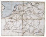
[MAP - FRANCE - GERMANY].
Nouvelle carte itinéraire, qui indique d'une manière très-exacte les routes et stations, ainsi que les distances des principales villes de France et dAllemagne.
Amsterdam, E. Maaskamp, [ca. 1810]. An engraved map printed on linen (ca. 33.5 x 43 cm.), partly coloured by hand in red and blue ink. Folded. Full description
€ 1,750
Amsterdam, E. Maaskamp, [ca. 1810]. An engraved map printed on linen (ca. 33.5 x 43 cm.), partly coloured by hand in red and blue ink. Folded. Full description