[SYRIA - EGYPTIAN EXPEDITIONARY FORCE].
Damascus.
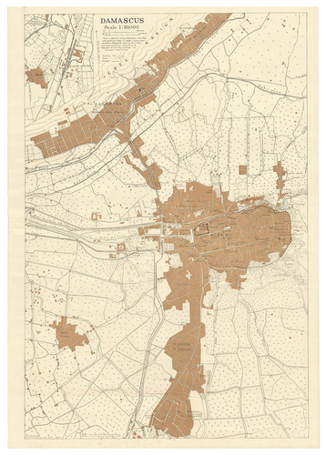
[Damascus?], Field Survey Co[mpan]y. R.E., E.E.F., 7 October 1918. Map of Damascus (73.5 x 51 cm) printed in black and tan, on a scale of 1:10,000.
€ 8,500
Extremely rare British map of Damascus, with a more detailed inset map of the area around Kadem Station (to the west of the city centre), the northern terminus of the Hejaz railway between Damascus and Medina, especially rare in its present first state, published by the British forces only a week after the fall of Damascus. Drafted by the Royal Engineers "from a captured enemy map (dated June 1918) with additional detail of Kadem Station from aeroplane photographs taken by the R.A.F." and printed under the surveyors supervision in the field, probably in Damascus, on a portable press carried by the Field Survey Company.
The ancient city of Damascus, one of the final prizes taken by the British and allied forces in World War I, was long a great cultural centre, the head of the Syrian Hajj Road, and more recently the northern terminus of the Hejaz Railway and the headquarters of the Ottoman-German forces in the Middle East. In the last months of the war, British forces met stiff resistance in Palestine, and it was only weeks before the end of the conflict that they managed to break into Syria. British forces and their allies captured the Damascus on 1 October 1918. Lawrence of Arabia, who was part of the conquering force, was disappointed not to have been amongst the first allied troops to enter the city, especially as he envisaged Damascus as the future capital of an independent and unified Arab state, and Prince Feisals army supported the British and allied forces with that understanding, unaware that the British and French in 1916 had made a secret agreement to divide the Ottoman territories outside the Arabian peninsula among themselves. Although Feisals troops did raise their flag in Damascus on 1 October and declare an independent Syrian state, it was in fact to be ruled as a French protectorate until 1945.
All maps printed by British and allied forces in the field in the Middle East during WWI are extreme rarities. The present map would have been issued in only a very small print run for the use of senior British officers, and printed on fragile paper in a large format, its survival rate would have been very low. We can trace only a single other example of the map in its present first state, held by the British Library. The British forces printed the map in a second state, with some revisions, for the Survey of Egypt in 1919, but it is also extremely rare in that second state.
In very good condition, clean and bright, with just some minor creasing from having been rolled for many years. British Library, Cartographic Items: Maps 48855.11; WorldCat 557017180 (same copy; cf. 557017192: 1 copy of 1919 revision).
Related Subjects: