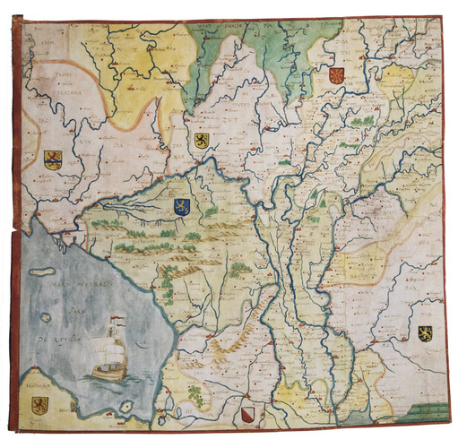
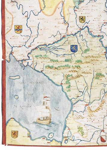
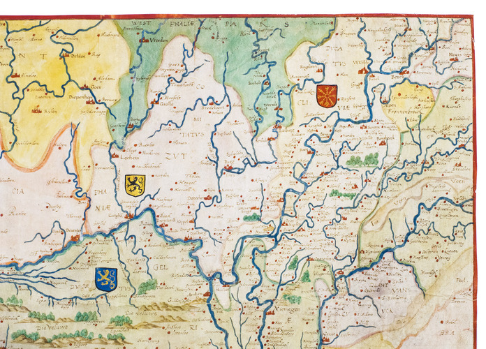
[MAP - GELDERLAND - MANUSCRIPT]. [SGROOTEN, Christiaan].
Gelderlant.
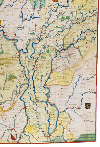
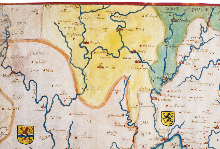
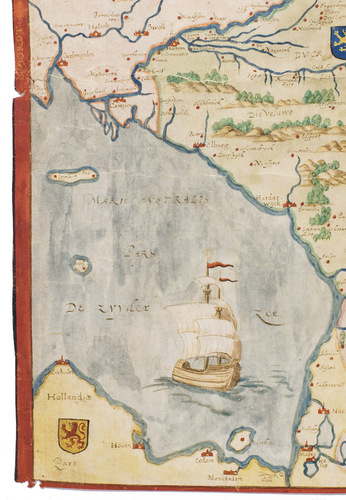
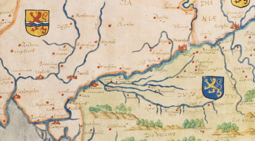
[Gelderland?], [ca. 1580/1600]. (36 x 37.5 cm; map image 35.5 x 36.5 cm). Manuscript map in coloured inks (and gold) on parchment (at a scale of about 1:315,000, with north to the left, covering about 51.4-52.8° N latitude and 4.9-6.8° E longitude), with 7 provincial coats of arms (rendered in colour and gold), three different variable scales (presumably intended as miles) in the lower right corner (2 units ranging from 30 to 45 mm) and a 6 cm square-rigged, two-masted ship in the Zuyder Zee. It shows rivers in dark blue, lakes and seas in light blue, hills in brown and trees in green, both highlighted with gold, and political regions both shaded and outlined in various colours. Cities and hundreds of towns and villages appear in red, the cities shown in profile with a gold dot, the others indicated by red dots, and all their names (and the names of regions) written quite clearly in brown ink. The whole map has a border in red ink on all four sides, with "Noordt" (North) lettered in gold capitals and small capitals in the right border.
€ 32,500
A manuscript map drawn in coloured inks on parchment showing the Duchy of Guelders (mostly now in the province of Gelderland) and surroundings, with north to the left. The Duchy itself is shown in light green with a slightly darker green border, the main (northern) part bounded by the Zuyder Zee (now the IJsselmeer) and the River Lek to the north, the River IJssel to the east and the River Maas to the south. The disjunct southern part of the Duchy is further south, up the River Maas, partly cut off at the right. The map was clearly intended to show the coats of arms (rendered in colour and gold) of the provinces (or before 1588 their predecessors) of Holland (county), Utrecht (lordship), Brabant (duchy), Overijsel (lordship), Gelderland (Duchy of Guelders), Zutphen (county) and Cleves (duchy). In fact, there appear to be two errors: the arms placed in Zutphen show a rampant lion, as expected, but the tinctures (colours) indicate the arms of Jülich rather than Zutphen; and the arms shown in Utrecht are not the arms of the lordship or province, but those of the city of Utrecht. Although the arms of Jülich and Guelders had been impaled for the Duchy of Guelders in 1377, they quickly reverted to the arms of Guelders alone, but from 1543 Karl V used both the arms of Guelders and the arms of Zutphen, and they were sometimes impaled together in the period 1543-1799, but in that period one also finds Guelders impaled with Jülich as in 1377, a form officially adopted by the province in 1802. The present map shows the arms of Guelders alone.
The scale is not entirely consistent, but measurements across the diagonals give figures ranging from 1:260,000 to 1:370,000. This would make the unnamed units in the scales closer to leagues than to miles, but those in a closely related manuscript map (see below) are even larger and are explicitly called miles.
The map as drawn has no title, but a contemporary hand has written "Gelderlant" on the back, running up the left edge as seen from the back, and partly trimmed off. An early manuscript note on the back in the upper left corner reads "Westphalen" (the westernmost part of Westphalia/Westphalen appears at the head of the map, coloured in a darker green). Below that is a larger number "44.", suggesting the map was one in a series or in a manuscript atlas. It and a similar manuscript map (Blonk & Van der Krogt, ill. 8.1 & p. 167) appear to have been based on a large wall map by Christiaan Sgrooten (ca. 1530-1603/08), drawn and engraved in the period 1558 to 1563 and probably first published in or shortly before 1567, though the in earliest state known to survive it is dated 1601 (still with the pre-1580 coat of arms of King Philip II of Spain, so probably not revised except for the publishers name and the date (Blonk & Van der Krogt, ill. 3.10 on p. 60). The two manuscript maps cover nearly the same region to the north and east, but the other extends slightly further west (the present just missing Amsterdam and the other just including it) and much further south than the present one. They match each other in style, have north to the right and show a very similar ship in Zuyder Zee, and both show the same error in the arms of Zutphen and show the Utrecht city arms for the Lordship of Utrecht. Sgrootens printed map has north at the top and covers the same region to the north, but extends slightly further than either manuscript map to the east and (like the other manuscript map) much further to the south, but it extends much further west than either manuscript map.
Both manuscript maps, however, include the city of Enkhuizen and part of its peninsula, which are hidden by a cartouche in Sgrootens printed map. The other manuscript map shows the arms of King Philip II of Spain in its post-1580 form (reflecting the union with Portugal), so it and no doubt also the present one were drawn after 1580. It also shows the arms of the Duchy of Guelders next to King Philips and equally large, rather than placing a smaller one in the region itself, as it does with other regions, suggesting that the maps were probably drawn by or at least for someone in Guelders. Major cities in the northern part of Guelders include Arnhem, Nijmegen, Harderwijk and Tiel. Cities outside Guelders that appear on the map include Deventer and Zutphen on the opposite bank of the river IJssel, and Utrecht, Zwolle, Kampen, Enkhuizen, Hoorn, Edam, Monnikendam, Amersfoort, Den Bosch, Cleves, Almelo, Wesel and many more. Apeldoorn, though now one of the largest cities in Gelderland, is represented only by a red dot: a papermaker first set up there in 1593, leading to its flourishing paper industry in the 17th century, but it was only after 1684, when the Dutch stadholder Willem III (the future King William III of England) bought the palace Het Loo in Apeldoorn to use as a hunting lodge, that it rose to prominence.
The borders at the head, foot and right probably had the compass directions lettered in gold, like the left border, but they have been trimmed closer to the map image. With a small tear through the left border, running a half-centimetre into the map image, a vertical crease about 8.5 cm from the right edge (so that it hardly touches the Duchy of Guelders), an irregular horizontal wrinkle across the middle and scattered smaller wrinkles, slightly affecting the drawn image, but still in good condition, with the colours fresh. An extremely detailed manuscript map of the Duchy of Guelders and surroundings, in coloured ink and gold, probably from the last decades of the 16th century. Dick Blonk & Peter van der Krogt, Geldria Ducatus: geschiedenis en cartobibliografie van het Hertogdom Gelderland, 2021, pp. 167-169 & ill. 8.2.
Related Subjects: