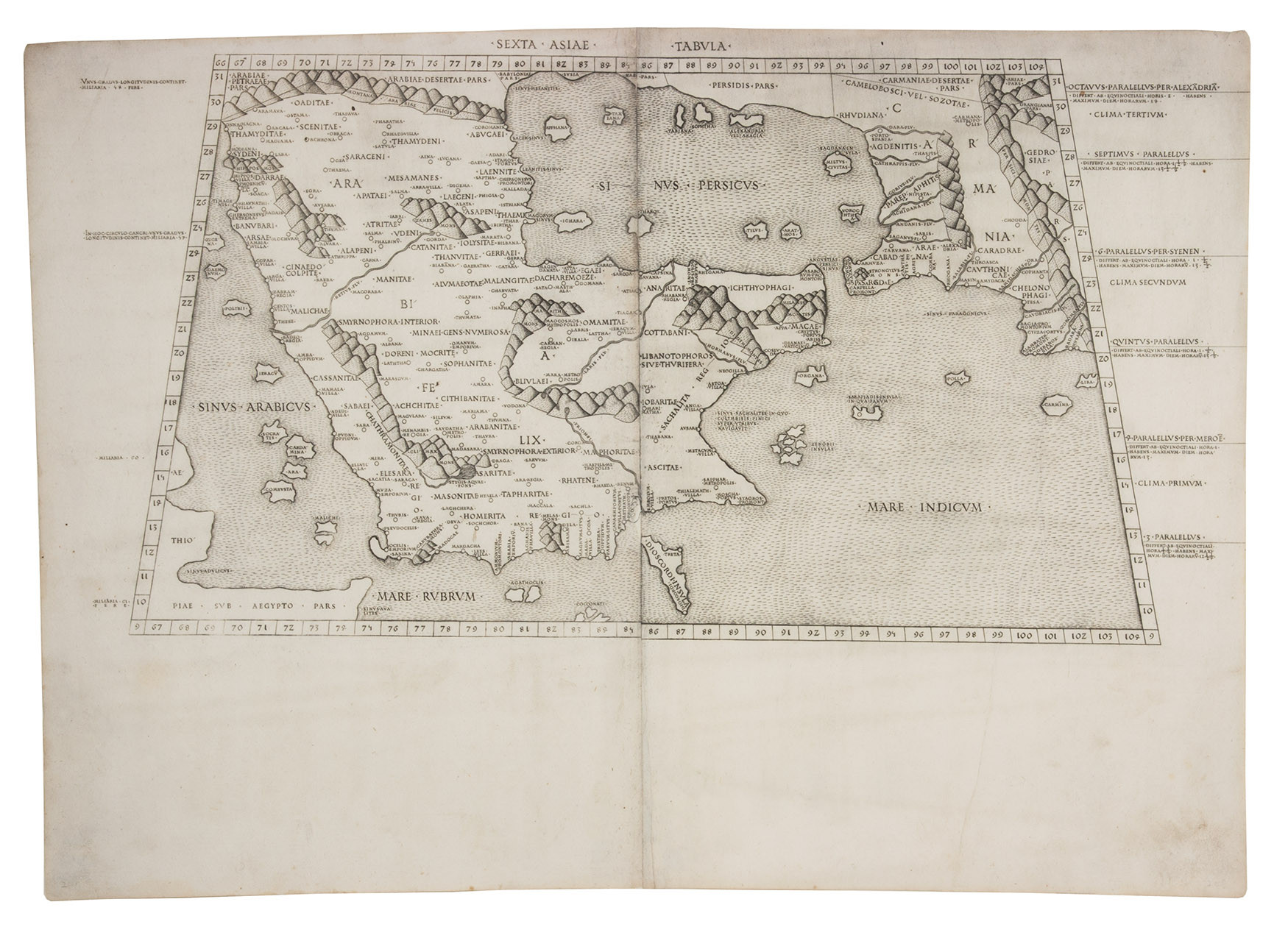
[MAP - ARABIAN PENINSULA]. PTOLEMAEUS, Claudius.
Sexta Asiae tabula.
[Rome, Petrus de Turre, 1490 (engraved Rome, ca. 1478)]. Engraved map of the Arabian peninsula (topographic image 25.5 x 46 cm) printed, as usual, on two joined folio leaves (together 39.5 x 56 cm). Mounted on paper board, in a modern gilt frame (50.5 x 67 cm).
€ 50,000
Second map of the Arabian peninsula ever published, in its first state. It was originally engraved as part of the extraordinary 1478 Rome edition of Ptolemys Geographia, and the map was preceded by only the one published in the less detailed and crudely engraved Bologna edition published in 1477. It shows the city of Medina (Lathrippa) and the archaeological sites of Zubarah (Catara), and Al-Dur (Domana). The association of Macoraba with Mecca is disputed.
The 1478 Geographia was created under the direction of Conrad Sweynheym, who together with Arnold Pannartz introduced printing to Italy, and after his death in 1477 finished by his successor Arnold Buckinck. The edition was planned as early as 1474 and possibly even 1473 and the plates were likely engraved before the publication of the 1477 Bologna edition. These two atlases contain the earliest copperplate maps ever produced and Sweynheyms careful experiments clearly paid off: "its firm, sure lines and crisp impression are in sharp contrast to the rather crudely engraved and muddily printed Bologna edition" (Karrow). "Many consider the Rome plates to be the finest Ptolemaic plates produced until Gerard Mercator engraved his classical world atlas of 1578" (Shirley). Christopher Columbus bought a copy.
The map was reprinted unchanged in the Rome edition of 1490, published by De Turre, and again in a 1507 edition, reissued in 1508. It is here printed on two folio leaves, each watermarked with a cardinal's hat (the two slightly different and probably the twins of a single paper stock). They are very close to Briquet 3391 (Florence 1491), so our map probably comes from the 1490 edition.
Some faint stains along the edges of the paper and in the gutter, small restoration in gutter of the lower margin and a very minor tear near the upper left corner. In good condition. Campbell, Earliest printed maps, map 141 & atlas D42 (pp. 131-133), cf. pp. 122-127, 223-225; Nordenskiöld 201, map 21; Tibbetts 4 note; cf. Al Ankary 3 (1511?); Karrow 32/B1 (atlas, 1478 ed.); Shirley, Maps in atlases T.POL-2c (atlas, 1490 ed.); Shirley, Mapping of the world 4 note (atlas, 1490 ed.).
Related Subjects: