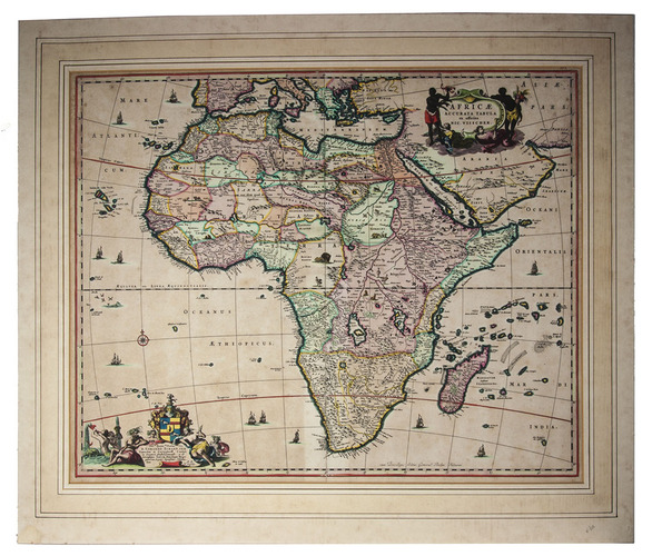
[MAP - AFRICA]. VISSCHER, Nicolaas.
Africae accurata tabula.
[Amsterdam], Nicolas Visscher, [ca. 1690?]. Engraved double-page map (image size: 43.5 x 54 cm; leaf size: 51 x 60 cm), coloured by a contemporary hand. With title in a decorated cartouche on the top right flanked by two Africans and two putti and dedication to Gerardus Schaap in a decorated cartouche on the bottom left, with Schaap's coat of arms on top and flanked by mythical figures. Further illustrated with small ships and African animals (including lions, monkeys, rhinoceros and ostriches). In passepartout (56 x 66 cm).
€ 2,500
Second state of Visscher's engraved map of Africa, with the privilege added to the bottom right. It shows the whole continent of Africa, the southern Mediterranean coast and a substantial part of the Arabian Peninsula. Primarily the coastline is accurately depicted, with great detail to the South African coastline in particular - the interior of Africa was not accurately mapped until the 19th century. This map was based on Willem Blaeu's map of 1608, and used in atlases by the Visscher family up to 1696.
With the centrefold strengthened at the back; paper browned and with a few small smudges, but the colouring still bright. Koeman, Vis 86*; V.d. Krogt & De Groot 35:04 (first state); Norwich, Africa 55.
Related Subjects: