About us
Contact
Services
Privacy policy
Terms of sale
Home
Shopping cart
(0 items
€ 0
)
European Euro (€)
U.S. Dollar ($)
U.K. Pound Sterling (£)
_______________________________________________
U.A.E Dirham (AED )
Afghan afghani (AFN )
Albanian lek (ALL )
Armenia Dram (AMD )
Angolan kwanza (AOA )
Argentine Peso (ARS )
Australian Dollar (A$)
Aruban florin (AWG )
Azerbaijan Manat (AZN )
Bosnia and Herzegovina convertible mark (BAM )
Barbadian Dollar (BBD )
Bangladeshi taka (BDT )
Bulgarian Lev (BGN )
Bahrain Dinar (BHD )
Burundian franc (BIF )
Brunei Dollar (BND )
Bolivian Boliviano (BOB )
Brazilian Real (R$)
Bahamian Dollar (BSD )
Botswana Pula (BWP )
Belarussian Ruble (BYN )
Belize dollar (BZD )
Canadian Dollar (CA$)
Congolese franc (CDF )
Swiss Franc (CHF )
Chilean Peso (CLP )
Chinese Yuan (CN¥)
Colombian Peso (COP )
Costa Rican Colón (CRC )
Cuban peso (CUP )
Cape Verde escudo (CVE )
Czech Koruna (CZK )
Djiboutian franc (DJF )
Danish Krone (DKK )
Dominican Peso (DOP )
Algerian Dinar (DZD )
Egyptian Pound (EGP )
Eritrean nakfa (ERN )
Ethiopian birr (ETB )
Fiji Dollar (FJD )
Georgian lari (GEL )
Ghanaian Cedi (GHS )
Gibraltar pound (GIP )
Gambian dalasi (GMD )
Guinean franc (GNF )
Guatemalan Quetzal (GTQ )
Guyanese dollar (GYD )
Hong Kong Dollar (HK$)
Honduran Lempira (HNL )
Haitian gourde (HTG )
Hungarian Forint (HUF )
Indonesian Rupiah (IDR )
Israeli New Sheqel (₪)
Indian Rupee (₹)
Iraqi dinar (IQD )
Iranian rial (IRR )
Icelandic Krona (ISK )
Jamaican Dollar (JMD )
Jordanian Dinar (JOD )
Japanese Yen (¥)
Kenyan shilling (KES )
Kyrgyzstan Som (KGS )
Cambodian riel (KHR )
Comoro franc (KMF )
South Korean Won (₩)
Kuwaiti Dinar (KWD )
Kazakhstani Tenge (KZT )
Lao kip (LAK )
Lebanese Pound (LBP )
Sri Lanka Rupee (LKR )
Liberian dollar (LRD )
Lesotho loti (LSL )
Libyan Dinar (LYD )
Moroccan Dirham (MAD )
Moldova Lei (MDL )
Malagasy ariary (MGA )
Macedonian denar (MKD )
Myanma Kyat (MMK )
Mongolian togrog (MNT )
Macanese pataca (MOP )
Mauritanian ouguiya (MRU )
Mauritian Rupee (MUR )
Maldivian rufiyaa (MVR )
Malawian kwacha (MWK )
Mexican Peso (MX$)
Malaysian Ringgit (MYR )
Mozambican metical (MZN )
Namibian dollar (NAD )
Nigerian Naira (NGN )
Nicaraguan Córdoba (NIO )
Norwegian Krone (NOK )
Nepalese Rupee (NPR )
New Zealand Dollar (NZ$)
Omani Rial (OMR )
Panamanian Balboa (PAB )
Peruvian Nuevo Sol (PEN )
Papua New Guinean kina (PGK )
Philippine Peso (₱)
Pakistani Rupee (PKR )
Polish Zloty (PLN )
Paraguayan Guaraní (PYG )
Qatari Rial (QAR )
Romanian New Leu (RON )
Serbian Dinar (RSD )
Russian Rouble (RUB )
Rwandan franc (RWF )
Saudi Riyal (SAR )
Solomon Islands dollar (SBD )
Seychelles rupee (SCR )
Sudanese pound (SDG )
Swedish Krona (SEK )
Singapore Dollar (SGD )
Somali shilling (SOS )
Surinamese dollar (SRD )
South Sudanese pound (SSP )
São Tomé and Príncipe Dobra (STN )
Salvadoran colon (SVC )
Syrian pound (SYP )
Swazi lilangeni (SZL )
Thai Baht (THB )
Tajikistan Ruble (TJS )
New Turkmenistan Manat (TMT )
Tunisian Dinar (TND )
Tongan paʻanga (TOP )
Turkish Lira (TRY )
Trinidad Tobago Dollar (TTD )
New Taiwan Dollar (NT$)
Tanzanian shilling (TZS )
Ukrainian Hryvnia (UAH )
Ugandan shilling (UGX )
Uruguayan Peso (UYU )
Uzbekistan Sum (UZS )
Venezuelan Bolivar (VES )
Vietnamese Dong (₫)
Vanuatu vatu (VUV )
Samoan tala (WST )
Central African CFA Franc (FCFA )
East Caribbean Dollar (EC$)
Caribbean guilder (XCG )
West African CFA Franc (F CFA )
CFP Franc (CFPF )
Yemeni rial (YER )
South African Rand (ZAR )
Zambian kwacha (ZMW )
Name
E-mail
Message
Send
Inquire
€ 0
Checkout
Inventory
Gallery
Fairs
Catalogues
Cartography & Exploration
Go Back
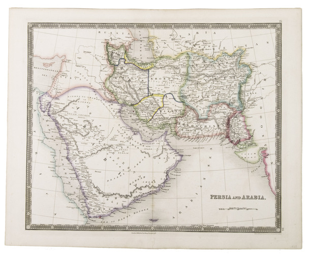
19th-century map of Arabia and Persia
TEESDALE, Henry.
Persia and Arabia.
London, 1847. Engraved map (41 x 33 cm), hand-coloured in outline.
€ 750
Al-Qasimi 243.
Order
Inquire
Terms of sale
Share this link
Your Name:*
Friend's E-mail:*
Share!
Name
E-mail
Message
Send
Related Subjects:
Cartography & exploration
>
Atlases, Charts, Maps & Globes
|
Middle East & Islamic World
Middle east & islamic world
>
Arabian Peninsula & Gulf States
|
Central & West Asia